File:The Square, Broughton-in-Furness - geograph.org.uk - 51180.jpg
From Wikishire
No higher resolution available.
The_Square,_Broughton-in-Furness_-_geograph.org.uk_-_51180.jpg (640 × 480 pixels, file size: 179 KB, MIME type: image/jpeg)
Summary
| Description |
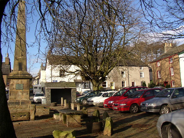
English: The Square, Broughton-in-Furness. Before the mid-18C, Broughton-in-Furness was a loose group of buildings strung out along the ancient coastal route, but after seeing in 1760 the new squares then being constructed in London, Gilpin Sawrey, the Lord of the Manor, made his own version. The square is lined by trees and surrounded by 18C buildings in terraces. The Obelisk of 1810 was erected for the Jubilee of George III. There are stone slabs for the display of fish etc in the market (no longer used). |
| Date | |
| Source | From geograph.org.uk |
| Author | Humphrey Bolton |
| Attribution (required by the license) | Humphrey Bolton / The Square, Broughton-in-Furness / |
| Object location | | View this and other nearby images on: OpenStreetMap |
|---|
_&language=en)
Licensing

|
This image was taken from the Geograph project collection. See this photograph's page on the Geograph website for the photographer's contact details. The copyright on this image is owned by Humphrey Bolton and is licensed for reuse under the Creative Commons Attribution-ShareAlike 2.0 license.
|
This file is licensed under the Creative Commons Attribution-Share Alike 2.0 Generic license.
Attribution: Humphrey Bolton
- You are free:
- to share – to copy, distribute and transmit the work
- to remix – to adapt the work
- Under the following conditions:
- attribution – You must give appropriate credit, provide a link to the license, and indicate if changes were made. You may do so in any reasonable manner, but not in any way that suggests the licensor endorses you or your use.
- share alike – If you remix, transform, or build upon the material, you must distribute your contributions under the same or compatible license as the original.
File history
Click on a date/time to view the file as it appeared at that time.
| Date/Time | Thumbnail | Dimensions | User | Comment | |
|---|---|---|---|---|---|
| current | 20:07, 30 January 2010 | | 640 × 480 (179 KB) | GeographBot | == {{int:filedesc}} == {{Information |description={{en|1=The Square, Broughton-in-Furness. Before the mid-18C, Broughton-in-Furness was a loose group of buildings strung out along the ancient coastal route, but after seeing in 1760 the new squares then be |
File usage
The following file is a duplicate of this file (more details):
- File:The Square, Broughton-in-Furness - geograph.org.uk - 51180.jpg from a shared repository
The following page links to this file: