File:The River Moy at Foxford - geograph.org.uk - 486800.jpg
From Wikishire
No higher resolution available.
The_River_Moy_at_Foxford_-_geograph.org.uk_-_486800.jpg (640 × 396 pixels, file size: 104 KB, MIME type: image/jpeg)
Summary
| Description |
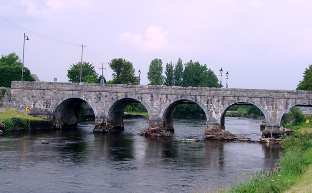
English: The River Moy at Foxford Marks on the pillars of the bridge show the height of the river water before the channel was deepened 40 years ago to alleviate flooding. The water used to cover the bank and path at the bottom right of the picture |
| Date | |
| Source | From geograph.org.uk |
| Author | Liz McCabe |
| Attribution (required by the license) | Liz McCabe / The River Moy at Foxford / |
| Camera location | | View this and other nearby images on: OpenStreetMap |
|---|
_heading:0.00&language=en)
| Object location | | View this and other nearby images on: OpenStreetMap |
|---|
_heading:0.00&language=en)
Licensing

|
This image was taken from the Geograph project collection. See this photograph's page on the Geograph website for the photographer's contact details. The copyright on this image is owned by Liz McCabe and is licensed for reuse under the Creative Commons Attribution-ShareAlike 2.0 license.
|
This file is licensed under the Creative Commons Attribution-Share Alike 2.0 Generic license.
Attribution: Liz McCabe
- You are free:
- to share – to copy, distribute and transmit the work
- to remix – to adapt the work
- Under the following conditions:
- attribution – You must give appropriate credit, provide a link to the license, and indicate if changes were made. You may do so in any reasonable manner, but not in any way that suggests the licensor endorses you or your use.
- share alike – If you remix, transform, or build upon the material, you must distribute your contributions under the same or compatible license as the original.
File history
Click on a date/time to view the file as it appeared at that time.
| Date/Time | Thumbnail | Dimensions | User | Comment | |
|---|---|---|---|---|---|
| current | 02:57, 5 February 2011 | | 640 × 396 (104 KB) | GeographBot | == {{int:filedesc}} == {{Information |description={{en|1=The River Moy at Foxford Marks on the pillars of the bridge show the height of the river water before the channel was deepened 40 years ago to alleviate flooding. The water used to cover the bank an |
File usage
The following file is a duplicate of this file (more details):
- File:The River Moy at Foxford - geograph.org.uk - 486800.jpg from a shared repository
The following page links to this file: