File:The Old Chapel, Creslow - geograph.org.uk - 234817.jpg
From Wikishire
No higher resolution available.
The_Old_Chapel,_Creslow_-_geograph.org.uk_-_234817.jpg (640 × 480 pixels, file size: 81 KB, MIME type: image/jpeg)
Summary
| Description |
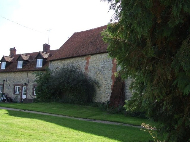
English: The Old Chapel, Creslow. This chapel is marked on the map and edged in black suggesting it is a public building, but it looks to me as though it has been incorporated into the adjoining building. The only signs were ones informing that there was no right of way for the public - so at best it probably has a very small congregation !
Edit: According to the English Heritage Viewfinder website "The former parish church, which ceased being used in the 18th century, was first a dovecot and is now used as an outbuilding of the Manor House. " ( See http://viewfinder.english-heritage.org.uk/search/reference.asp?index=385&imageUID=51561&main_query=&theme=&period=&county=&district=&place_name=Ham ) However the BHO website (see http://www.british-history.ac.uk/report.aspx?compid=42572&strquery=Parish%20Creslow#s3 ) itself quoting the "History of the County of Buckingham" suggests that it had not been used as a church since the time of Elizabeth I (1558-1603). A list of the rectors (see http://met.open.ac.uk/genuki/big/eng/BKM/Creslow/rectors.html ) finishes with the appointment of Thomas Davis A.M. in 1554 - which serves to confirm this earlier date.
|
|
| Date | ||
| Source | From geograph.org.uk | |
| Author | Rob Farrow | |
| Attribution (required by the license) | Rob Farrow / The Old Chapel, Creslow / | |
| Object location | | View this and other nearby images on: OpenStreetMap |
|---|
_heading:135.00&language=en)
Licensing

|
This image was taken from the Geograph project collection. See this photograph's page on the Geograph website for the photographer's contact details. The copyright on this image is owned by Rob Farrow and is licensed for reuse under the Creative Commons Attribution-ShareAlike 2.0 license.
|
This file is licensed under the Creative Commons Attribution-Share Alike 2.0 Generic license.
Attribution: Rob Farrow
- You are free:
- to share – to copy, distribute and transmit the work
- to remix – to adapt the work
- Under the following conditions:
- attribution – You must give appropriate credit, provide a link to the license, and indicate if changes were made. You may do so in any reasonable manner, but not in any way that suggests the licensor endorses you or your use.
- share alike – If you remix, transform, or build upon the material, you must distribute your contributions under the same or compatible license as the original.
File history
Click on a date/time to view the file as it appeared at that time.
| Date/Time | Thumbnail | Dimensions | User | Comment | |
|---|---|---|---|---|---|
| current | 02:29, 1 February 2010 | | 640 × 480 (81 KB) | GeographBot | == {{int:filedesc}} == {{Information |description={{en|1=The Old Chapel, Creslow. This chapel is marked on the map and edged in black suggesting it is a public building, but it looks to me as though it has been incorporated into the adjoining building. Th |
File usage
The following file is a duplicate of this file (more details):
- File:The Old Chapel, Creslow - geograph.org.uk - 234817.jpg from a shared repository
The following page links to this file: