File:Sutton Hoo map.svg
From Wikishire

Size of this preview: 354 × 417 pixels. Other resolution: 204 × 240 pixels.
Original file (SVG file, nominally 354 × 417 pixels, file size: 116 KB)
Summary
| Description |
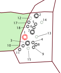
English: Sutton Hoo map |
| Date | 15 July 2011 (original upload date) |
| Source | Own work, based on map of the Sutton Hoo burial ground, in Carver, Martin, 'Sutton Hoo:Burial Ground of Kings?' , p. 135 (ISBN 0-7141-0599-6) and OS map of the Sutton Hoo burial group (http://www.old-maps.co.uk/maps.html?txtXCoord=628798&txtYCoord=248700). Mound burials in black, possible mound burials in grey, woodland in green, from Carver, p. 179. |
| Author | Amitchell125 at English Wikipedia |
Licensing
Amitchell125 at English Wikipedia, the copyright holder of this work, hereby publishes it under the following license:
This file is licensed under the Creative Commons Attribution-Share Alike 3.0 Unported license.
Attribution: Amitchell125 at English Wikipedia
- You are free:
- to share – to copy, distribute and transmit the work
- to remix – to adapt the work
- Under the following conditions:
- attribution – You must give appropriate credit, provide a link to the license, and indicate if changes were made. You may do so in any reasonable manner, but not in any way that suggests the licensor endorses you or your use.
- share alike – If you remix, transform, or build upon the material, you must distribute your contributions under the same or compatible license as the original.
Original upload log
Transferred from en.wikipedia to Commons by James Steakley using CommonsHelper.
The original description page was here. All following user names refer to en.wikipedia.
- 2011-07-15 18:58 Amitchell125 354×417× (118350 bytes) Given white background, reduced file size.
- 2011-07-15 18:55 Amitchell125 354×417× (1740630 bytes) Own work, based on map of the Sutton Hoo burial ground, in Carver, Martin, 'Sutton Hoo:Burial Ground of Kings?' , p. 135 ({{ISBN|0-7141-0599-6}}) and OS map of the Sutton Hoo burial group (http://www.old-maps.co.uk/maps.html?txtXCoord=628798&txtYCoord=248700)
File history
Click on a date/time to view the file as it appeared at that time.
| Date/Time | Thumbnail | Dimensions | User | Comment | |
|---|---|---|---|---|---|
| current | 23:00, 7 May 2013 | | 354 × 417 (116 KB) | OgreBot | (BOT): Reverting to most recent version before archival |
File usage
The following file is a duplicate of this file (more details):
- File:Sutton Hoo map.svg from a shared repository
The following page links to this file: