File:Stourport-on-Severn OS map 1942.jpg
From Wikishire
Size of this preview: 800 × 549 pixels. Other resolution: 320 × 220 pixels.
Original file (874 × 600 pixels, file size: 373 KB, MIME type: image/jpeg)
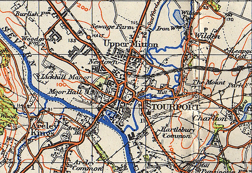
| Description | w:Stourport-on-Severn and surrounding area |
| Date | |
| Source | w:Ordnance Survey map one-inch sheet 71 (Second War Revision 1940) entitled "Kidderminster" |
| Author | Map by w:Ordnance Survey; scan by User:Loganberry |
This work is an Ordnance Survey map over 50 years old, which is covered by Crown Copyright which in this case expires 50 years after publication. Ordnance Survey does however ask that they be credited and that the date of publication be given.
Any ancillary rights gained through the creation of the electronic version are granted as freely usable under any circumstances.
|
This work created by the United Kingdom Government is in the public domain.
This is because it is one of the following:
HMSO has declared that the expiry of Crown Copyrights applies worldwide (ref: HMSO Email Reply)
|
 |
This scan was made from a 1942-era OS map (revised 1940, as stated above). Text at foot of sheet reads "Geographical Section, General Staff. No. 3907." and "Published at the War Office, 1942." Now in the public domain because of its age - see licence tag above.
File history
Click on a date/time to view the file as it appeared at that time.
| Date/Time | Thumbnail | Dimensions | User | Comment | |
|---|---|---|---|---|---|
| current | 23:23, 10 May 2007 | | 874 × 600 (373 KB) | Loganberry~commonswiki | {{Information |Description=w:Stourport-on-Severn and surrounding area |Source=w:Ordnance Survey map one-inch sheet 71 (Second War Revision 1940) entitled "Kidderminster" |Date=1942 |Author=Map by w:Ordnance Survey; scan by User:Loganberry |
File usage
The following file is a duplicate of this file (more details):
- File:Stourport-on-Severn OS map 1942.jpg from a shared repository
The following page links to this file: