File:St Mawes Castle - geograph.org.uk - 561873.jpg
From Wikishire
No higher resolution available.
St_Mawes_Castle_-_geograph.org.uk_-_561873.jpg (640 × 480 pixels, file size: 148 KB, MIME type: image/jpeg)
Summary
| Description |
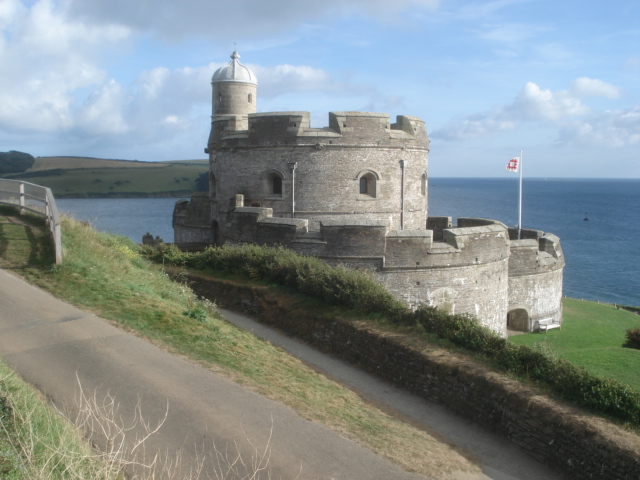
English: St Mawes Castle Looking southwards from near the car park. The best preserved and most elaborately decorated of Henry VIIIs coastal fortresses, St Mawes was built to counter invasion threats from France and Spain. Its counterpart, Pendennis, is on the other side of the Fal estuary. The clover-leaf shaped fort fell easily to landward attack by Parliamentarian forces in 1646 and was not properly refortified until the late 19th and early 20th centuries. |
| Date | |
| Source | From geograph.org.uk |
| Author | Trevor Rickard |
| Attribution (required by the license) | Trevor Rickard / St Mawes Castle / |
| Camera location | | View this and other nearby images on: OpenStreetMap |
|---|
_heading:157.00&language=en)
| Object location | | View this and other nearby images on: OpenStreetMap |
|---|
_heading:157.00&language=en)
Licensing

|
This image was taken from the Geograph project collection. See this photograph's page on the Geograph website for the photographer's contact details. The copyright on this image is owned by Trevor Rickard and is licensed for reuse under the Creative Commons Attribution-ShareAlike 2.0 license.
|
This file is licensed under the Creative Commons Attribution-Share Alike 2.0 Generic license.
Attribution: Trevor Rickard
- You are free:
- to share – to copy, distribute and transmit the work
- to remix – to adapt the work
- Under the following conditions:
- attribution – You must give appropriate credit, provide a link to the license, and indicate if changes were made. You may do so in any reasonable manner, but not in any way that suggests the licensor endorses you or your use.
- share alike – If you remix, transform, or build upon the material, you must distribute your contributions under the same or compatible license as the original.
File history
Click on a date/time to view the file as it appeared at that time.
| Date/Time | Thumbnail | Dimensions | User | Comment | |
|---|---|---|---|---|---|
| current | 07:43, 6 February 2011 | | 640 × 480 (148 KB) | GeographBot | == {{int:filedesc}} == {{Information |description={{en|1=St Mawes Castle Looking southwards from near the car park. The best preserved and most elaborately decorated of Henry VIIIs coastal fortresses, St Mawes was built to counter invasion threats from |
File usage
The following file is a duplicate of this file (more details):
- File:St Mawes Castle - geograph.org.uk - 561873.jpg from a shared repository
The following page links to this file: