File:St Julian's and St Alkmund's Churches, Shrewsbury - geograph.org.uk - 117067.jpg
From Wikishire

Size of this preview: 408 × 599 pixels. Other resolution: 163 × 240 pixels.
Original file (429 × 630 pixels, file size: 77 KB, MIME type: image/jpeg)
Summary
| Description |
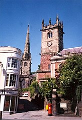
English: St Julian's and St Alkmund's Churches, Shrewsbury. Medieval towns usually have large numbers of churches, often close together. St Alkmund's Church (on the left) was rebuilt in 1793-5 retaining the medieval tower and spire. St Julian's Church similarly has a tower built c.1200, with later upper stages in Perpendicular style, but the nave rebuilt in 1749-50 and the south side, partly visible in this photo, decorated by Classical Tuscan pilasters in 1846. The narrow road between the churches is Fish Street. The building on the left is 1 High Street and was built in the early 19C. It has a 16C timber-framed wing at the rear. The roof is hidden behind a parapet. Note the street light fastened to the wall of the building. |
| Date | |
| Source | From geograph.org.uk |
| Author | Humphrey Bolton |
| Attribution (required by the license) | Humphrey Bolton / St Julian's and St Alkmund's Churches, Shrewsbury / |
| Object location | | View this and other nearby images on: OpenStreetMap |
|---|
_&language=en)
Licensing

|
This image was taken from the Geograph project collection. See this photograph's page on the Geograph website for the photographer's contact details. The copyright on this image is owned by Humphrey Bolton and is licensed for reuse under the Creative Commons Attribution-ShareAlike 2.0 license.
|
This file is licensed under the Creative Commons Attribution-Share Alike 2.0 Generic license.
Attribution: Humphrey Bolton
- You are free:
- to share – to copy, distribute and transmit the work
- to remix – to adapt the work
- Under the following conditions:
- attribution – You must give appropriate credit, provide a link to the license, and indicate if changes were made. You may do so in any reasonable manner, but not in any way that suggests the licensor endorses you or your use.
- share alike – If you remix, transform, or build upon the material, you must distribute your contributions under the same or compatible license as the original.
File history
Click on a date/time to view the file as it appeared at that time.
| Date/Time | Thumbnail | Dimensions | User | Comment | |
|---|---|---|---|---|---|
| current | 21:58, 15 June 2011 | | 429 × 630 (77 KB) | Gnesener1900 | straightened |
File usage
The following file is a duplicate of this file (more details):
- File:St Julian's and St Alkmund's Churches, Shrewsbury - geograph.org.uk - 117067.jpg from a shared repository
The following page links to this file: