File:St John the Baptist, Sutterby - geograph.org.uk - 474339.jpg
From Wikishire
No higher resolution available.
St_John_the_Baptist,_Sutterby_-_geograph.org.uk_-_474339.jpg (640 × 480 pixels, file size: 107 KB, MIME type: image/jpeg)
Summary
| Description |
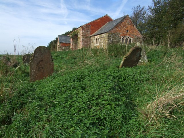
English: St John the Baptist, Sutterby The church of St John the Baptist became redundant on 24-Aug-1972 and was bequeathed as a gift to the Friends of Friendless Churches on 18-Mar-1981. The church is closed, and the interior is bare save for altar rail and screen. It has a bricked-up Norman doorway in the north wall and a porch of 1743. The tiny church only seated 40 people.
An opening in the west wall has been left for owls and other creatures. I poked my camera through the opening and fired without using flash and was amazed by what I saw on screen later. It was most unexpected. Church and graves. |
| Date | |
| Source | From geograph.org.uk |
| Author | Dave Hitchborne |
| Attribution (required by the license) | Dave Hitchborne / St John the Baptist, Sutterby / |
| Camera location | | View this and other nearby images on: OpenStreetMap |
|---|
_heading:292.00&language=en)
| Object location | | View this and other nearby images on: OpenStreetMap |
|---|
_heading:292.00&language=en)
Licensing

|
This image was taken from the Geograph project collection. See this photograph's page on the Geograph website for the photographer's contact details. The copyright on this image is owned by Dave Hitchborne and is licensed for reuse under the Creative Commons Attribution-ShareAlike 2.0 license.
|
This file is licensed under the Creative Commons Attribution-Share Alike 2.0 Generic license.
Attribution: Dave Hitchborne
- You are free:
- to share – to copy, distribute and transmit the work
- to remix – to adapt the work
- Under the following conditions:
- attribution – You must give appropriate credit, provide a link to the license, and indicate if changes were made. You may do so in any reasonable manner, but not in any way that suggests the licensor endorses you or your use.
- share alike – If you remix, transform, or build upon the material, you must distribute your contributions under the same or compatible license as the original.
File history
Click on a date/time to view the file as it appeared at that time.
| Date/Time | Thumbnail | Dimensions | User | Comment | |
|---|---|---|---|---|---|
| current | 23:25, 4 February 2011 | | 640 × 480 (107 KB) | GeographBot | == {{int:filedesc}} == {{Information |description={{en|1=St John the Baptist, Sutterby The church of St John the Baptist became redundant on 24-Aug-1972 and was bequeathed as a gift to the Friends of Friendless Churches on 18-Mar-1981. The church is close |
File usage
The following file is a duplicate of this file (more details):
- File:St John the Baptist, Sutterby - geograph.org.uk - 474339.jpg from a shared repository
The following page links to this file: