File:Spare gun on the rock.jpg
From Wikishire

Size of this preview: 800 × 442 pixels. Other resolution: 320 × 177 pixels.
Original file (4,752 × 2,628 pixels, file size: 10.15 MB, MIME type: image/jpeg)
Summary
| Description |
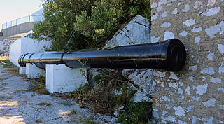
English: spare gun between O'Hara's and Lord Airey's Batteries. These are located at the highest point on the Rock of Gibraltar at a height of 426 meters (1,383 ft). The Batteries are built on the site of O'Hara's Tower and named after Governor General Charles O'Hara. O'Hara had believed that, if a watchtower was constructed on the highest point of the Rock, the Garrison would be able to observe the Spanish fleet at Cadiz. O'Hara's Tower was not successful in its intended purpose and was therefore nicknamed O'Hara's Folly.
The 9.2 inch Mark X Coastal Defence Guns at O'Hara's, Lord Airey's and Spur Batteries had a range of 29,600 yds which easily covered both the Straits of Gibraltar (25,500 yds) and the Bay of Gibraltar (9,000 yds). |
| Date | |
| Source | https://www.flickr.com/photos/mosh70/8971042104/ |
| Author | Moshi Anahory |
| Camera location | | View this and other nearby images on: OpenStreetMap |
|---|
Licensing
| This image was originally posted to Flickr. Its license was verified as "cc-by-sa-2.0" by the UploadWizard Extension at the time it was transferred to Commons. See the license information for further details. |
This file is licensed under the Creative Commons Attribution-Share Alike 2.0 Generic license.
- You are free:
- to share – to copy, distribute and transmit the work
- to remix – to adapt the work
- Under the following conditions:
- attribution – You must give appropriate credit, provide a link to the license, and indicate if changes were made. You may do so in any reasonable manner, but not in any way that suggests the licensor endorses you or your use.
- share alike – If you remix, transform, or build upon the material, you must distribute your contributions under the same or compatible license as the original.
File history
Click on a date/time to view the file as it appeared at that time.
| Date/Time | Thumbnail | Dimensions | User | Comment | |
|---|---|---|---|---|---|
| current | 20:09, 1 July 2013 | | 4,752 × 2,628 (10.15 MB) | Victuallers | User created page with UploadWizard |
File usage
The following file is a duplicate of this file (more details):
- File:Spare gun on the rock.jpg from a shared repository
The following page links to this file: