File:South Orkney Islands-en.svg
From Wikishire

Size of this preview: 800 × 476 pixels. Other resolution: 320 × 190 pixels.
Original file (SVG file, nominally 2,303 × 1,370 pixels, file size: 252 KB)
Summary
| Description |
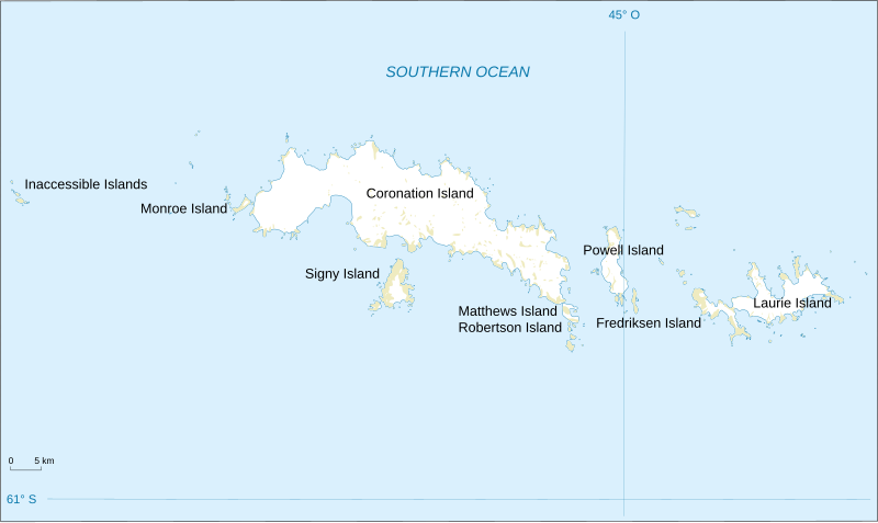
English: Map of South Orkney Islands.
Français : Carte des Iles Orcades du Sud.
Italiano: Mappa delle Isole Orcadi Meridionali. |
| Date | |
| Source | Landsat Image Mosaic Of Antarctica (LIMA) |
| Author | Shakki |
| Other versions |
|


Licensing
This image is in the public domain in the United States because it only contains materials that originally came from the United States Geological Survey, an agency of the United States Department of the Interior. For more information, see the official USGS copyright policy.
|
File history
Click on a date/time to view the file as it appeared at that time.
| Date/Time | Thumbnail | Dimensions | User | Comment | |
|---|---|---|---|---|---|
| current | 18:32, 17 March 2008 | | 2,303 × 1,370 (252 KB) | Shakki | {{Information |Description={{en|Map of South Orkney Islands}} {{fr|Carte des Iles Orcades du Sud}} |Source=[http://gisdata.usgs.gov/website/antarctic_research_atlas/ Landsat Image Mosaic Of Antarctica (LIMA)] |Date=Mar 2008 |Author=Shakki |
File usage
The following file is a duplicate of this file (more details):
- File:South Orkney Islands-en.svg from a shared repository
The following page links to this file: