File:Somerleyton swing bridge - geograph.org.uk - 1506014.jpg
From Wikishire
No higher resolution available.
Somerleyton_swing_bridge_-_geograph.org.uk_-_1506014.jpg (640 × 395 pixels, file size: 91 KB, MIME type: image/jpeg)
Summary
| Description |
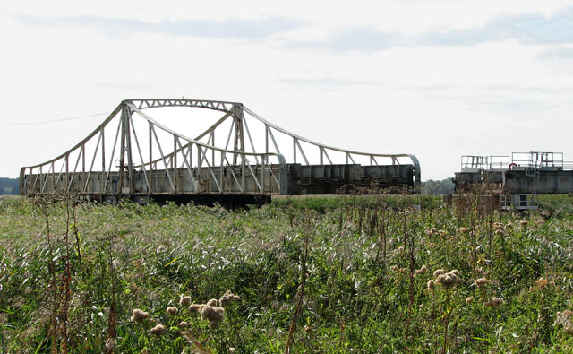
English: Somerleyton swing bridge. The bridge is closed to rail traffic in order to let a boat pass that is travelling on the River Waveney. The view to the river is obscured by the high reeds growing alongside both sides of it. For a view of the bridge as it swings around and re-connects with the rail track see > 1506020.
Somerleyton swing bridge > https://www.geograph.org.uk/photo/1506009 - it is located a short distance to the north-west of Somerleyton railway station > https://www.geograph.org.uk/photo/1505978 and takes the railway line over the River Waveney - is 14.40 metres wide and has a clearance f 2.60 metres. The bridge is kept in alignment with the rails on the land by means of a bolt. The signals on the far side of the bridge are connected mechanically and carried across the length of the bridge on rods. The signal box > https://www.geograph.org.uk/photo/1506027 is a brick-built example of the Great Eastern's standard design which was introduced in 1886, and it is quite large because the bridge operating gear used to occupy part of the box. Outside there is a board that can be used to indicate to shipping how long they will have to wait, other boards can be slid across to indicate the waiting time. For a view of the signal box and bridge taken from Somerleyton station see > https://www.geograph.org.uk/photo/1505959. |
| Date | |
| Source | From geograph.org.uk |
| Author | Evelyn Simak |
| Attribution (required by the license) | Evelyn Simak / Somerleyton swing bridge / |
| Camera location | | View this and other nearby images on: OpenStreetMap |
|---|
_heading:202.00&language=en)
| Object location | | View this and other nearby images on: OpenStreetMap |
|---|
_heading:202.00&language=en)
Licensing

|
This image was taken from the Geograph project collection. See this photograph's page on the Geograph website for the photographer's contact details. The copyright on this image is owned by Evelyn Simak and is licensed for reuse under the Creative Commons Attribution-ShareAlike 2.0 license.
|
This file is licensed under the Creative Commons Attribution-Share Alike 2.0 Generic license.
Attribution: Evelyn Simak
- You are free:
- to share – to copy, distribute and transmit the work
- to remix – to adapt the work
- Under the following conditions:
- attribution – You must give appropriate credit, provide a link to the license, and indicate if changes were made. You may do so in any reasonable manner, but not in any way that suggests the licensor endorses you or your use.
- share alike – If you remix, transform, or build upon the material, you must distribute your contributions under the same or compatible license as the original.
File history
Click on a date/time to view the file as it appeared at that time.
| Date/Time | Thumbnail | Dimensions | User | Comment | |
|---|---|---|---|---|---|
| current | 21:42, 2 March 2011 | | 640 × 395 (91 KB) | GeographBot | == {{int:filedesc}} == {{Information |description={{en|1=Somerleyton swing bridge The bridge is closed to rail traffic in order to let a boat pass that is travelling on the River Waveney. The view to the river is obscured by the high reeds growing alongsi |
File usage
The following file is a duplicate of this file (more details):
- File:Somerleyton swing bridge - geograph.org.uk - 1506014.jpg from a shared repository
The following page links to this file: