File:SlieveLeague ToneMapped.jpg
From Wikishire

Size of this preview: 800 × 427 pixels. Other resolution: 320 × 171 pixels.
Original file (1,024 × 546 pixels, file size: 411 KB, MIME type: image/jpeg)
Summary
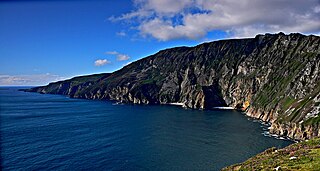
Les falaises de Slieve League, dans le comté de Donegal en Irlande, sont les plus hautes falaises d'Europe en culminant à 606 mètres d'altitude. Les couleurs de cette image ont été retouchées avec The Gimp.
Licensing
This file is licensed under the Creative Commons Attribution-Share Alike 2.5 Generic license.
- You are free:
- to share – to copy, distribute and transmit the work
- to remix – to adapt the work
- Under the following conditions:
- attribution – You must give appropriate credit, provide a link to the license, and indicate if changes were made. You may do so in any reasonable manner, but not in any way that suggests the licensor endorses you or your use.
- share alike – If you remix, transform, or build upon the material, you must distribute your contributions under the same or compatible license as the original.
File history
Click on a date/time to view the file as it appeared at that time.
| Date/Time | Thumbnail | Dimensions | User | Comment | |
|---|---|---|---|---|---|
| current | 15:09, 27 February 2007 | | 1,024 × 546 (411 KB) | Snoow~commonswiki | Les falaises de Slieve League, dans le comté de Donegal en Irlande, sont les plus hautes falaises d'Europe en culminant à 606 mètres d'altitude. Les couleurs de cette image ont été retouchées avec The Gimp. |
File usage
The following file is a duplicate of this file (more details):
- File:SlieveLeague ToneMapped.jpg from a shared repository
The following 3 pages link to this file: