File:Silverstone Circuit 2010 version.png

From Wikishire
Jump to: navigation, search
Original file(1,912 × 1,198 pixels, file size: 96 KB, MIME type: image/png)

This file is from a shared repository and may be used by other projects. The description on its file description page there is shown below.

Summary

Description
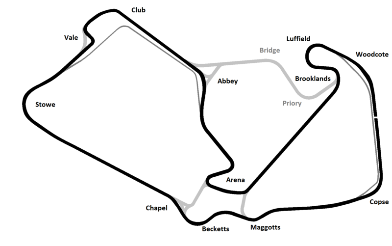
English: The new "Arena Grand Prix" version of Silverstone Circuit.
This map was created from OpenStreetMap project data, collected by the community. This map may be incomplete, and may contain errors. Don't rely solely on it for navigation.
Date
Source openstreetmap.org
Creator
junafanil
 
This PNG graphic was created with GIMP.
OpenStreetMap contributors
Permission
(Reusing this file)
OpenStreetMap data and maps are licensed under the Creative Commons Attribution-ShareAlike 2.0 license (CC-BY-SA 2.0).
w:en:Creative Commons
attribution share alike
This file is licensed under the Creative Commons Attribution-Share Alike 2.0 Generic license.
You are free:
  • to share – to copy, distribute and transmit the work
  • to remix – to adapt the work
Under the following conditions:
  • attribution – You must give appropriate credit, provide a link to the license, and indicate if changes were made. You may do so in any reasonable manner, but not in any way that suggests the licensor endorses you or your use.
  • share alike – If you remix, transform, or build upon the material, you must distribute your contributions under the same or compatible license as the original.
Georeferencing Georeference the map in Wikimaps Warper If inappropriate please set warp_status = skip to hide.
Other versions
File:Silverstone circuit.svg is a vector version of this file. It should be used in place of this PNG file when not inferior.

File:Silverstone Circuit 2010 version.png → File:Silverstone circuit.svg

For more information, see Help:SVG.

In other languages
Alemannisch  Bahasa Indonesia  Bahasa Melayu  British English  català  čeština  dansk  Deutsch  eesti  English  español  Esperanto  euskara  français  Frysk  galego  hrvatski  Ido  italiano  lietuvių  magyar  Nederlands  norsk bokmål  norsk nynorsk  occitan  Plattdüütsch  polski  português  português do Brasil  română  Scots  sicilianu  slovenčina  slovenščina  suomi  svenska  Tiếng Việt  Türkçe  vèneto  Ελληνικά  беларуская (тарашкевіца)  български  македонски  нохчийн  русский  српски / srpski  татарча/tatarça  українська  ქართული  հայերեն  বাংলা  தமிழ்  മലയാളം  ไทย  한국어  日本語  简体中文  繁體中文  עברית  العربية  فارسی  +/−
New SVG image

This file has been superseded by Silverstone circuit.svg. It is recommended to use the other file. Please note that deleting superseded images requires consent.
new file
This road map image could be re-created using vector graphics as an SVG file. This has several advantages; see Commons:Media for cleanup for more information. If an SVG form of this image is available, please upload it and afterwards replace this template with {{vector version available|new image name}}.


It is recommended to name the SVG file “Silverstone Circuit 2010 version.svg”—then the template Vector version available (or Vva) does not need the new image name parameter.


Camera location54° 04′ 43″ N, 1° 01′ 01″ W Kartographer map based on OpenStreetMap.View this and other nearby images on: OpenStreetMapinfo

Captions

Add a one-line explanation of what this file represents

Items portrayed in this file

depicts

54°4'43.000"N, 1°1'0.998"W

File history

Click on a date/time to view the file as it appeared at that time.

Date/TimeThumbnailDimensionsUserComment
current13:07, 19 October 2014Thumbnail for version as of 13:07, 19 October 20141,912 × 1,198 (96 KB)Gustavo GirardelliReverted to version as of 14:32, 15 February 2010

The following file is a duplicate of this file (more details):

The following page links to this file: