File:ShepardMap802Northumbria.png
From Wikishire

Size of this preview: 467 × 599 pixels. Other resolution: 187 × 240 pixels.
Original file (650 × 834 pixels, file size: 359 KB, MIME type: image/png)
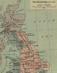
A detail from William Shepherd's map of the British Isles about 802 AD, showing the kingdom of Northumbria and neighboring domains. Mapa de William Shepherd de las Islas Britanicas alrededor de 802, se muestra los reinos de Northumbria, Bernicia, Deira, y otros
source: http://www.lib.utexas.edu/maps/historical/shepherd/british_isles_802.jpg
This work is in the public domain because it was published in the United States between 1929 and 1963, and although there may or may not have been a copyright notice, the copyright was not renewed. For further explanation, see Commons:Hirtle chart and the copyright renewal logs. Note that it may still be copyrighted in jurisdictions that do not apply the rule of the shorter term for US works (depending on the date of the author's death), such as Canada (70 years p.m.a.), Mainland China (50 years p.m.a., not Hong Kong or Macao), Germany (70 years p.m.a.), Mexico (100 years p.m.a.), Switzerland (70 years p.m.a.), and other countries with individual treaties.
|
 |
File history
Click on a date/time to view the file as it appeared at that time.
| Date/Time | Thumbnail | Dimensions | User | Comment | |
|---|---|---|---|---|---|
| current | 02:18, 1 August 2016 | | 650 × 834 (359 KB) | JohnnyMrNinja | compression and file indexing |
File usage
The following file is a duplicate of this file (more details):
- File:ShepardMap802Northumbria.png from a shared repository
The following page links to this file: