File:River Mole Map.png
From Wikishire
No higher resolution available.
River_Mole_Map.png (447 × 544 pixels, file size: 67 KB, MIME type: image/png)
Summary
| Description |
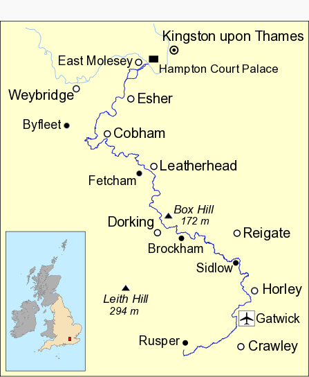
English: Map of River Mole in south east England showing part of the River Thames. Data from Open Street Maps. |
| Date | |
| Source | Own work |
| Author | Mertbiol |
| Other versions | River Mole Map.svg |
Licensing
| I, the copyright holder of this work, release this work into the public domain. This applies worldwide. In some countries this may not be legally possible; if so: I grant anyone the right to use this work for any purpose, without any conditions, unless such conditions are required by law. |
File history
Click on a date/time to view the file as it appeared at that time.
| Date/Time | Thumbnail | Dimensions | User | Comment | |
|---|---|---|---|---|---|
| current | 14:25, 8 October 2010 | | 447 × 544 (67 KB) | Mertbiol | Sort out colouring and make rivers bolder. |
File usage
The following file is a duplicate of this file (more details):
- File:River Mole Map.png from a shared repository
The following page links to this file: