File:RiverSevernMap.jpg
From Wikishire

Size of this preview: 675 × 600 pixels. Other resolution: 270 × 240 pixels.
Original file (871 × 774 pixels, file size: 389 KB, MIME type: image/jpeg)
Summary


source: http://en.wikipedia.org/wiki/Image:RiverSevernMap.jpg
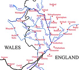
| Description | Map of River Severn's watershed, updated version with more Welsh settlements. |
| Date | |
| Source | Own work |
| Author | ChrisJB (talk) |
| Other versions |
 |
Licensing
I, the copyright holder of this work, hereby publish it under the following license:
This file is licensed under the Creative Commons Attribution 3.0 Unported license.
- You are free:
- to share – to copy, distribute and transmit the work
- to remix – to adapt the work
- Under the following conditions:
- attribution – You must give appropriate credit, provide a link to the license, and indicate if changes were made. You may do so in any reasonable manner, but not in any way that suggests the licensor endorses you or your use.
File history
Click on a date/time to view the file as it appeared at that time.
| Date/Time | Thumbnail | Dimensions | User | Comment | |
|---|---|---|---|---|---|
| current | 23:14, 16 July 2008 | | 871 × 774 (389 KB) | Ori~ | source: http://en.wikipedia.org/wiki/Image:RiverSevernMap.jpg {{Information |Description=Map of the River Severn, updated version with more Welsh settlements. |Source=self-made |Date=29 March 2008 |Location= |Author=ChrisJB ([[User t |
File usage
The following file is a duplicate of this file (more details):
- File:RiverSevernMap.jpg from a shared repository
The following page links to this file: