File:Pontmap2b.jpg
From Wikishire

Size of this preview: 499 × 599 pixels. Other resolution: 200 × 240 pixels.
Original file (1,348 × 1,618 pixels, file size: 685 KB, MIME type: image/jpeg)
Summary
| Description |
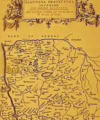
English: pont's map circa 1700's showing area of coatbridge and Glasgow. Note: Author is deader than disco |
| Date | 17th century |
| Source | Scan from the original work |
| Author | Timothy Pont (c. 1565–1614) |
Licensing
|
This work is in the public domain in its country of origin and other countries and areas where the copyright term is the author's life plus 100 years or fewer. | |
| This file has been identified as being free of known restrictions under copyright law, including all related and neighboring rights. | |
Original upload log
The original description page was here. All following user names refer to en.wikipedia.
| Date/Time | Dimensions | User | Comment |
|---|---|---|---|
| 2009-02-27 22:11 | 1348×1618× (701356 bytes) | Jayhoolihan | pont's map circa 1700's showing area of coatbridge and glasgow. author is deader than disco |
File history
Click on a date/time to view the file as it appeared at that time.
| Date/Time | Thumbnail | Dimensions | User | Comment | |
|---|---|---|---|---|---|
| current | 21:49, 5 September 2014 | | 1,348 × 1,618 (685 KB) | Hogweard | Transferred from en.wikipedia |
File usage
The following file is a duplicate of this file (more details):
- File:Pontmap2b.jpg from a shared repository
The following page links to this file: