File:P&A betweenChichesterandArundelreduced.png

Summary
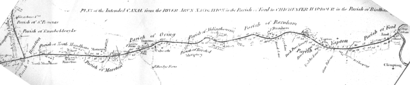
| Description | 1815 plan for the section of the Portsmouth and Arundel Canal to be built between the brach to chichester and the river arun |
| Date | |
| Source | 1815 map |
| Author | Netlam & Francis Giles (although the shape of the cost line and such is probably taken from other older maps) |
| Permission (Reusing this file) |
PD due to age |
| Other versions | larger versionImage:P&A betweenChichesterandArundel.png |
Licensing
|
This work is in the public domain in its country of origin and other countries and areas where the copyright term is the author's life plus 70 years or fewer.
| |
| This file has been identified as being free of known restrictions under copyright law, including all related and neighboring rights. | |
File history
Click on a date/time to view the file as it appeared at that time.
| Date/Time | Thumbnail | Dimensions | User | Comment | |
|---|---|---|---|---|---|
| current | 02:28, 30 May 2007 | 1,440 × 298 (122 KB) | Geni | == Summary == {{Information |Description=1815 plan for the section of the Portsmouth and Arundel Canal to be built between the brach to chichester and the river arun |Source=1815 map |Date=1815 |Author=Netlam & Francis Giles (although the shape of the co |
File usage
The following file is a duplicate of this file (more details):
- File:P&A betweenChichesterandArundelreduced.png from a shared repository
The following page links to this file: