File:Old Schoolhouse, Haskayne - geograph.org.uk - 282287.jpg
From Wikishire
No higher resolution available.
Old_Schoolhouse,_Haskayne_-_geograph.org.uk_-_282287.jpg (640 × 480 pixels, file size: 72 KB, MIME type: image/jpeg)
Summary
| Description |
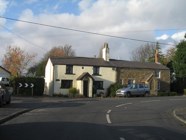
English: Old Schoolhouse, Haskayne Situated at the junction of Black-A-Moor lane with School Lane, this old schoolhouse dated 1802, served the farming communities of Downholland and Haskayne. Founded long before the Education Act of 1870, in the early days the children had to pay a small amount to their teacher towards her stipend and for the slates and chalks that was provided for them. The earliest recorded teachers are Catherine Mawdsley and her daughter Eliza Yates, who followed her mother into the post of headmistress in the 1850s. The old schoolhouse was replaced by a larger building in 1890 which itself has now been replaced by a modern building partly funded by the Scarisbrick family, lords of the manor. The two older buildings are now both private residences. |
| Date | |
| Source | From geograph.org.uk |
| Author | Sue Adair |
| Attribution (required by the license) | Sue Adair / Old Schoolhouse, Haskayne / |
| Camera location | | View this and other nearby images on: OpenStreetMap |
|---|
_heading:292.00&language=en)
| Object location | | View this and other nearby images on: OpenStreetMap |
|---|
_heading:292.00&language=en)
Licensing

|
This image was taken from the Geograph project collection. See this photograph's page on the Geograph website for the photographer's contact details. The copyright on this image is owned by Sue Adair and is licensed for reuse under the Creative Commons Attribution-ShareAlike 2.0 license.
|
This file is licensed under the Creative Commons Attribution-Share Alike 2.0 Generic license.
Attribution: Sue Adair
- You are free:
- to share – to copy, distribute and transmit the work
- to remix – to adapt the work
- Under the following conditions:
- attribution – You must give appropriate credit, provide a link to the license, and indicate if changes were made. You may do so in any reasonable manner, but not in any way that suggests the licensor endorses you or your use.
- share alike – If you remix, transform, or build upon the material, you must distribute your contributions under the same or compatible license as the original.
- Remove redundant categories and try to put this image in the most specific category/categories
- Remove this template
- The location categories are based on information from this geonames tool and this OpenStreetMap tool combined with a database. You can also have a look at this tool from mysociety.
- The topic category from Geograph was School (converted) (find similar images (converted) at Geograph)
File history
Click on a date/time to view the file as it appeared at that time.
| Date/Time | Thumbnail | Dimensions | User | Comment | |
|---|---|---|---|---|---|
| current | 19:45, 14 December 2010 | | 640 × 480 (72 KB) | GeographBot | == {{int:filedesc}} == {{Information |description={{en|1=Old Schoolhouse, Haskayne Situated at the junction of Black-A-Moor lane with School Lane, this old schoolhouse dated 1802, served the farming communities of Downholland and Haskayne. Founded long be |
File usage
The following file is a duplicate of this file (more details):
- File:Old Schoolhouse, Haskayne - geograph.org.uk - 282287.jpg from a shared repository
The following page links to this file: