File:Oakham labelled.png

From Wikishire
Jump to: navigation, search
Original file(1,782 × 1,980 pixels, file size: 1,007 KB, MIME type: image/png)

This file is from a shared repository and may be used by other projects. The description on its file description page there is shown below.

This road map image could be re-created using vector graphics as an SVG file. This has several advantages; see Commons:Media for cleanup for more information. If an SVG form of this image is available, please upload it and afterwards replace this template with {{vector version available|new image name}}.


It is recommended to name the SVG file “Oakham labelled.svg”—then the template Vector version available (or Vva) does not need the new image name parameter.
Description
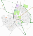
This map was created from OpenStreetMap project data, collected by the community. This map may be incomplete, and may contain errors. Don't rely solely on it for navigation.
Date (see file history)
Source You may find a page on the OpenStreetMap wiki page for Oakham
Creator
OpenStreetMap contributors
Permission
(Reusing this file)
OpenStreetMap data and maps are licensed under the Creative Commons Attribution-ShareAlike 2.0 license (CC-BY-SA 2.0).
w:en:Creative Commons
attribution share alike
This file is licensed under the Creative Commons Attribution-Share Alike 2.0 Generic license.
You are free:
  • to share – to copy, distribute and transmit the work
  • to remix – to adapt the work
Under the following conditions:
  • attribution – You must give appropriate credit, provide a link to the license, and indicate if changes were made. You may do so in any reasonable manner, but not in any way that suggests the licensor endorses you or your use.
  • share alike – If you remix, transform, or build upon the material, you must distribute your contributions under the same or compatible license as the original.
Georeferencing Georeference the map in Wikimaps Warper If inappropriate please set warp_status = skip to hide.


Creating the map

Data was collected by volunteers at the Rutland Mapping party over one weekend using handheld GPS devices, notebooks, digital cameras, and voice recordings

Map was edited using JOSM software to mark roads, rivers, etc. over the top of the tracklogs showing where people had travelled

Map was rendered using Osmarender software, to produce the outlined roads, symbols, labels, etc.

SVG map was edited using Inkscape to place labels in more readable positions

Map was exported from Inkscape to the PNG file shown here

Data files

Attributions

  • List of people who collected the data is available on the mapping party planning page
  • Includes other data that already in the OpenStreetMap project's map
  • Label editing done by OJW

Notes

Map includes two sections of bypass which are still in construction

Captions

Add a one-line explanation of what this file represents

Items portrayed in this file

depicts

File history

Click on a date/time to view the file as it appeared at that time.

Date/TimeThumbnailDimensionsUserComment
current11:27, 21 October 2006Thumbnail for version as of 11:27, 21 October 20061,782 × 1,980 (1,007 KB)Ojw~commonswiki{{openstreetmap|name=Oakham}}

The following file is a duplicate of this file (more details):

The following page links to this file: