File:Newtownlow.JPG
From Wikishire

Size of this preview: 800 × 599 pixels. Other resolution: 320 × 239 pixels.
Original file (2,288 × 1,712 pixels, file size: 2.86 MB, MIME type: image/jpeg)
Summary
| Description |
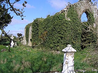
English: Ruined church at Newtownlow, near Kilbeggan |
| Date | |
| Source | Own work |
| Author | Blackrock78 at English Wikipedia |
Licensing
Blackrock78 at English Wikipedia, the copyright holder of this work, hereby publishes it under the following licenses:
This file is licensed under the Creative Commons Attribution-Share Alike 3.0 Unported license.
Attribution: Blackrock78 at English Wikipedia
- You are free:
- to share – to copy, distribute and transmit the work
- to remix – to adapt the work
- Under the following conditions:
- attribution – You must give appropriate credit, provide a link to the license, and indicate if changes were made. You may do so in any reasonable manner, but not in any way that suggests the licensor endorses you or your use.
- share alike – If you remix, transform, or build upon the material, you must distribute your contributions under the same or compatible license as the original.

|
Permission is granted to copy, distribute and/or modify this document under the terms of the GNU Free Documentation License, Version 1.2 or any later version published by the Free Software Foundation; with no Invariant Sections, no Front-Cover Texts, and no Back-Cover Texts. A copy of the license is included in the section entitled GNU Free Documentation License. |
You may select the license of your choice.
Original upload log
Transferred from en.wikipedia to Commons by Coyau using CommonsHelper.
The original description page was here. All following user names refer to en.wikipedia.
- 2008-03-16 14:54 Blackrock78 2288×1712× (2996931 bytes) {{Information |Description= |Source=self-made |Date= |Location= |Author=~~~ |other_versions= }}
| Object location | | View this and other nearby images on: OpenStreetMap |
|---|

|
This object is indexed in the Archaeological Survey of Ireland under SMR No. WM038-012----
Geographic information system of the National Monuments Service: Historic Environment Viewer – Database record. |
File history
Click on a date/time to view the file as it appeared at that time.
| Date/Time | Thumbnail | Dimensions | User | Comment | |
|---|---|---|---|---|---|
| current | 16:23, 7 March 2009 | | 2,288 × 1,712 (2.86 MB) | File Upload Bot (Magnus Manske) | {{BotMoveToCommons|en.wikipedia|year={{subst:CURRENTYEAR}}|month={{subst:CURRENTMONTHNAME}}|day={{subst:CURRENTDAY}}}} {{Information |Description={{en|Ruined church at Newtownlow, near Kilbeggan}} |Source=Transferred from [http://en.wikipedia.org en.wiki |
File usage
The following file is a duplicate of this file (more details):
- File:Newtownlow.JPG from a shared repository
The following page links to this file: