File:Moyry Castle, Geograph.jpg
From Wikishire

Size of this preview: 450 × 600 pixels. Other resolution: 180 × 240 pixels.
Original file (480 × 640 pixels, file size: 112 KB, MIME type: image/jpeg)
| Camera location | | View this and other nearby images on: OpenStreetMap |
|---|
| Object location | | View this and other nearby images on: OpenStreetMap |
|---|
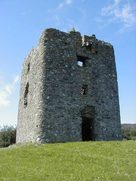
| Description | Moyry Castle is situated in County Armagh, Northern Ireland. It was built in 1601 by Lord Mountjoy to help secure Moyry Pass and the Gap of the North. It is set in the corner of a small bawn and is a small rectangular tower three storeys high. | ||
| Date | |||
| Source | Geograph project | ||
| Author | Ron Murray | ||
| Permission (Reusing this file) |
This file is licensed under the Creative Commons Attribution-Share Alike 2.0 Generic license. Attribution: Ron Murray
|

_region:GB-NIR_heading:135.00&language=en)
_region:GB-NIR_heading:135.00&language=en)
File history
Click on a date/time to view the file as it appeared at that time.
| Date/Time | Thumbnail | Dimensions | User | Comment | |
|---|---|---|---|---|---|
| current | 13:41, 24 November 2006 | | 480 × 640 (112 KB) | GeeJo | {{Information| |Description = Moyry Castle is situated in County Armagh, Northern Ireland. It was built in 1601 by Lord Mountjoy to help secure Moyry Pass and the Gap of the North. It is set in the corner of a small bawn and is a smal |
File usage
The following file is a duplicate of this file (more details):
- File:Moyry Castle, Geograph.jpg from a shared repository
The following page links to this file: