File:Moirlanich Longhouse - geograph.org.uk - 278876.jpg
From Wikishire

Size of this preview: 800 × 600 pixels. Other resolution: 320 × 240 pixels.
Original file (3,264 × 2,448 pixels, file size: 1.55 MB, MIME type: image/jpeg)
| Description |
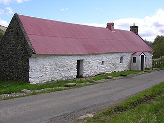
 English: Moirlanich Longhouse at grid reference NN 562 341, looking east-northeast, in Glen Lochay near Killin in the Stirling council area in Scotland. Described by the National Trust, who now own it, as "a rare example of a Scottish longhouse - a type of building in which a family and their livestock lived under one roof". Entry on NTS website. |
| Date | |
| Source | via RHaworth |
| Author | John Adams |
| Object location | | View this and other nearby images on: OpenStreetMap |
|---|
|

_region:GB-GBN_heading:67.00&language=en)
File history
Click on a date/time to view the file as it appeared at that time.
| Date/Time | Thumbnail | Dimensions | User | Comment | |
|---|---|---|---|---|---|
| current | 11:58, 3 February 2010 | | 3,264 × 2,448 (1.55 MB) | RHaworth | {{Information |Description=Moirlanich Longhouse |Source={{own}} |Date= |Author=RHaworth |Permission= |other_versions= }} {{subst:user:RHaworth/mylic}} |
File usage
The following file is a duplicate of this file (more details):
- File:Moirlanich Longhouse - geograph.org.uk - 278876.jpg from a shared repository
The following page links to this file: