File:Michelsen Island south of Powell Island - South Orkney Islands, BAT.svg
From Wikishire

Size of this preview: 105 × 151 pixels. Other resolution: 167 × 240 pixels.
Original file (SVG file, nominally 105 × 151 pixels, file size: 164 KB)
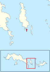
Summary
| Description | Location of Michelsen Island south of Powell Island in the South Orkney Islands, in the British Antarctic Territory |
| Date | |
| Source | Data from British Antarctic Survey Geodata Portal - Antarctic Digital Database |
| Author |
British Antarctic Survey
|
| Permission (Reusing this file) |
This file is licensed under the Creative Commons Attribution 4.0 International license. Attribution: Antarctic Digital Database
|
File history
Click on a date/time to view the file as it appeared at that time.
| Date/Time | Thumbnail | Dimensions | User | Comment | |
|---|---|---|---|---|---|
| current | 20:28, 21 May 2022 | | 105 × 151 (164 KB) | Hogweard | == {{int:filedesc}} == {{Information |description=Location of Michelsen Island south of Powell Island in the South Orkney Islands, in the British Antarctic Territory |date=2020-01-21 |source={{BAS data|source}} |author={{BAS data|author}} *Derivative work: {{u|Hogweard}} |permission={{BAS data}} |other versions= }} Category:Maps of the South Orkney Islands |
File usage
The following file is a duplicate of this file (more details):
- File:Michelsen Island south of Powell Island - South Orkney Islands, BAT.svg from a shared repository
The following page links to this file: