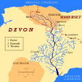
File:Map of the River Exe - Exe highlighted.svg

From Wikishire
Jump to: navigation, search
Original file(SVG file, nominally 600 × 600 pixels, file size: 82 KB)

This file is from a shared repository and may be used by other projects. The description on its file description page there is shown below.

Summary

Description
English: Map of river Exe and its drainage basin
Русский: Карта реки Экс и её бассейна
Date
Source Own work
Author =*User:Small Bug|Small Bug*derivative work: Hogweard
Permission
(Reusing this file)
Public domain I, the copyright holder of this work, release this work into the public domain. This applies worldwide.
In some countries this may not be legally possible; if so:
I grant anyone the right to use this work for any purpose, without any conditions, unless such conditions are required by law.
Other versions Map_of_River_Exe_ru.svg
 
This W3C-unspecified vector image was created with Inkscape .
This is a retouched picture, which means that it has been digitally altered from its original version. Modifications: Added county boundary and moors. The original can be viewed here: Map of River Exe en.svg. Modifications made by Hogweard.

Licensing

Public domain I, the copyright holder of this work, release this work into the public domain. This applies worldwide.
In some countries this may not be legally possible; if so:
I grant anyone the right to use this work for any purpose, without any conditions, unless such conditions are required by law.

Captions

Add a one-line explanation of what this file represents

Items portrayed in this file

depicts

6 April 2014

File history

Click on a date/time to view the file as it appeared at that time.

Date/TimeThumbnailDimensionsUserComment
current20:09, 26 July 2017Thumbnail for version as of 20:09, 26 July 2017600 × 600 (82 KB)Delta 51typo corrected (Exmooth -> Exmouth)

The following file is a duplicate of this file (more details):

The following page links to this file: