File:Map-Roehampton.png
From Wikishire
Size of this preview: 364 × 599 pixels. Other resolution: 146 × 240 pixels.
Original file (374 × 615 pixels, file size: 103 KB, MIME type: image/png)
Summary
| Description |
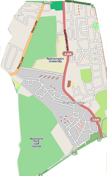
English: Map of Roehampton district |
| Date | |
| Source | www.openstreetmap.org |
| Author | Open Street Map |
Licensing
This file is licensed under the Creative Commons Attribution-Share Alike 2.5 Generic license.
- You are free:
- to share – to copy, distribute and transmit the work
- to remix – to adapt the work
- Under the following conditions:
- attribution – You must give appropriate credit, provide a link to the license, and indicate if changes were made. You may do so in any reasonable manner, but not in any way that suggests the licensor endorses you or your use.
- share alike – If you remix, transform, or build upon the material, you must distribute your contributions under the same or compatible license as the original.
File history
Click on a date/time to view the file as it appeared at that time.
| Date/Time | Thumbnail | Dimensions | User | Comment | |
|---|---|---|---|---|---|
| current | 07:37, 6 May 2009 | | 374 × 615 (103 KB) | BHJ | {{Information |Description={{en|1=Map of Roehampton district}} |Source=www.openstreetmap.org |Author=Open Street Map |Date=May 6 2009 |Permission=See below |other_versions= }} <!--{{ImageUpload|full}}--> Category:London maps [[Category:Wandsworth map |
File usage
The following file is a duplicate of this file (more details):
- File:Map-Roehampton.png from a shared repository
The following page links to this file: