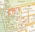
File:Lordship House, Tottenham 1619.jpg

From Wikishire
Jump to: navigation, search
Lordship_House,_Tottenham_1619.jpg(466 × 431 pixels, file size: 198 KB, MIME type: image/jpeg)

This file is from a shared repository and may be used by other projects. The description on its file description page there is shown below.

Summary

Description
English: detail of the 1619 map of the Parish of Tottenham, Middlesex (now in the London Borough of Haringey)
Date
Source Tottenham Parish Plan 1619
Author Thomas Clay[1]
Permission
(Reusing this file)
Public domain

This work is in the public domain in its country of origin and other countries and areas where the copyright term is the author's life plus 100 years or fewer.


You must also include a United States public domain tag to indicate why this work is in the public domain in the United States.

References

  1. Park Management Plan (PDF). Haringey Council (15 January 2009) Retrieved on 17 March 2009.[dead link]

Captions

Add a one-line explanation of what this file represents

Items portrayed in this file

depicts

File history

Click on a date/time to view the file as it appeared at that time.

Date/TimeThumbnailDimensionsUserComment
current10:42, 31 August 2008Thumbnail for version as of 10:42, 31 August 2008466 × 431 (198 KB)Iridescent== Summary == {{Information |Description={{en|1=detail of the 1619 map of the Parish of Tottenham, Middlesex (now in the London Borough of Haringey)}} |Source=Tottenham Parish Plan 1619 |Author=Survey on behalf of the Earl of Dorset |Date=1619 |Permission

The following file is a duplicate of this file (more details):

The following page links to this file: