File:Lord's Cricket Stadium Panoramic.jpg
From Wikishire

Size of this preview: 797 × 106 pixels. Other resolution: 320 × 43 pixels.
Original file (21,323 × 2,836 pixels, file size: 10.65 MB, MIME type: image/jpeg)
Summary
| Warning | The original file is very high-resolution. It might not load properly or could cause your browser to freeze when opened at full size. |
|---|
| Description |
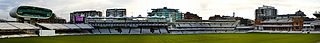
English: Lord's Cricket Ground (generally known as Lord's) is a cricket venue in St John's Wood, London. Named after its founder, Thomas Lord, it is owned by Marylebone Cricket Club (MCC) and is the home of Middlesex County Cricket Club, the England and Wales Cricket Board (ECB), the European Cricket Council (ECC) and, until August 2005, the International Cricket Council (ICC). Lord's is widely referred to as the "home of cricket" and is home to the world's oldest sporting museum. |
| Date | |
| Source | Lord's Cricket Stadium Panoramic |
| Author | Natesh Ramasamy from Bangalore, India |
| Other versions | Derivative works of this file: Lord's Cricket Stadium banner.jpg |
| Camera location | | View this and other nearby images on: OpenStreetMap |
|---|
Licensing
This file is licensed under the Creative Commons Attribution 2.0 Generic license.
- You are free:
- to share – to copy, distribute and transmit the work
- to remix – to adapt the work
- Under the following conditions:
- attribution – You must give appropriate credit, provide a link to the license, and indicate if changes were made. You may do so in any reasonable manner, but not in any way that suggests the licensor endorses you or your use.
| This image was originally posted to Flickr by Natesh Ramasamy at https://www.flickr.com/photos/19204893@N00/6654285893. It was reviewed on 2 December 2012 by FlickreviewR and was confirmed to be licensed under the terms of the cc-by-2.0. |
File history
Click on a date/time to view the file as it appeared at that time.
| Date/Time | Thumbnail | Dimensions | User | Comment | |
|---|---|---|---|---|---|
| current | 00:00, 2 December 2012 | 21,323 × 2,836 (10.65 MB) | Armbrust | {{Information |Description=[http://en.wikipedia.org/wiki/Lord en.wikipedia.org/wiki/Lord's_Cricket_Ground] Lord's Cricket Ground (generally known as Lord's) is a cricket venue in St John's Wood, London. Named after its founder, Thomas Lord, it is owne... |
File usage
The following file is a duplicate of this file (more details):
- File:Lord's Cricket Stadium Panoramic.jpg from a shared repository
The following page links to this file: