File:Livingston-Island-Map-2010-15.jpg
From Wikishire

Size of this preview: 799 × 600 pixels. Other resolution: 320 × 240 pixels.
Original file (5,337 × 4,006 pixels, file size: 3.26 MB, MIME type: image/jpeg)
Summary
| Description |
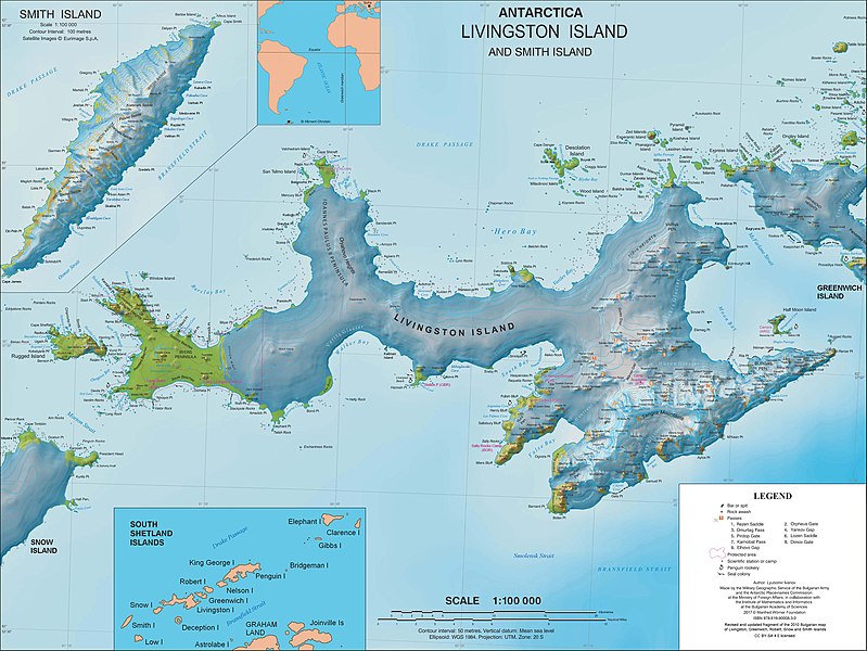
English: L.L. Ivanov. Antarctica: Livingston Island and Smith Island. Scale 1:100000 topographic map. Manfred Wörner Foundation, 2017. ISBN 978-619-90008-3-0 |
| Date | |
| Source | Livingston-Island-Map-2010-15.png |
| Author | |
| Permission (Reusing this file) |
Published by the Manfred Wörner Foundation under the Creative Commons Attribution ShareAlike 4.0 license. |
| Other versions |

|
This image is a JPEG version of the original PNG image at File: Livingston-Island-Map-2010-15.png.
Generally, this JPEG version should be used when displaying the file from Commons, in order to reduce the file size of thumbnail images. However, any edits to the image should be based on the original PNG version in order to prevent generation loss, and both versions should be updated. Do not make edits based on this version. See here for more information. |
Licensing
I, the copyright holder of this work, hereby publish it under the following license:
This file is licensed under the Creative Commons Attribution-Share Alike 4.0 International license.
- You are free:
- to share – to copy, distribute and transmit the work
- to remix – to adapt the work
- Under the following conditions:
- attribution – You must give appropriate credit, provide a link to the license, and indicate if changes were made. You may do so in any reasonable manner, but not in any way that suggests the licensor endorses you or your use.
- share alike – If you remix, transform, or build upon the material, you must distribute your contributions under the same or compatible license as the original.
File history
Click on a date/time to view the file as it appeared at that time.
| Date/Time | Thumbnail | Dimensions | User | Comment | |
|---|---|---|---|---|---|
| current | 06:35, 26 April 2019 | | 5,337 × 4,006 (3.26 MB) | Hogweard | == {{int:filedesc}} == {{Information |Description={{en|1=L.L. Ivanov. Antarctica: Livingston Island and Smith Island. Scale 1:100000 topographic map. Manfred Wörner Foundation, 2017. {{ISBN|978-619-90008-3-0}}}} |Source={{f|Livingston-Island-Map-2010-15.png}} |Author=*{{f|Livingston-Island-Map-2010-15.png}}: {{u|Apcbg}} |Date=2017-03-31 |Permission=Published by the Manfred Wörner Foundation under the Creative Commons Attribution ShareAlike 4.0 license. |other_versions=*{{f|Livingston-Island-M... |
File usage
The following file is a duplicate of this file (more details):
- File:Livingston-Island-Map-2010-15.jpg from a shared repository
The following page links to this file: