File:Lighthouses at Spurn Head - geograph.org.uk - 200519.jpg
From Wikishire
No higher resolution available.
Lighthouses_at_Spurn_Head_-_geograph.org.uk_-_200519.jpg (640 × 477 pixels, file size: 73 KB, MIME type: image/jpeg)
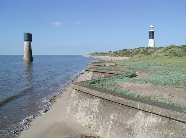
Spurn Low Light (left) is listed -
This is a photo of listed building number 1346603. |
Spurn High Light (right) is also listed -
This is a photo of listed building number 1083476. |
Summary
| Description |
English: Lighthouses at Spurn Point, East Riding of Yorkshire, England. The first reference to a lighthouse on Spurn dates back to 1427 when a hermit, William Reedbarrow, was granted dues from passing ships to complete a lighthouse he was building there. In the late seventeenth century high and low lights were erected on what was then the tip of the spit, probably about two miles north of the present tip. The low light had to be rebuilt several times but the high light lasted until the late eighteenth century when John Smeaton, the celebrated engineer who had built the Eddystone lighthouse in 1759, designed and built two new lighthouses at Spurn under the direction of the Hull and London Trinity Houses. In 1852 a new low lighthouse was built on the Humber foreshore and in 1895 the high one was also replaced because there was evidence that the foundations of Smeaton's lighthouse were giving way. The low lighthouse was then redundant since lights shone out at several levels from the new one, and it was used to store explosives for a while before being topped by a water storage tank. The high lighthouse shone out over Spurn until 1985 when modern technology meant that it too became redundant [information provided by wilgilsland.co.uk]. |
| Date | |
| Source | From geograph.org.uk |
| Author | Paul Glazzard |
| Permission (Reusing this file) |
Creative Commons Attribution Share-alike license 2.0 |
| Attribution (required by the license) | Paul Glazzard / Lighthouses at Spurn Head / |
| Camera location | | View this and other nearby images on: OpenStreetMap |
|---|
_heading:45.00&language=en)
| Object location | | View this and other nearby images on: OpenStreetMap |
|---|
_heading:45.00&language=en)
Licensing

|
This image was taken from the Geograph project collection. See this photograph's page on the Geograph website for the photographer's contact details. The copyright on this image is owned by Paul Glazzard and is licensed for reuse under the Creative Commons Attribution-ShareAlike 2.0 license.
|
This file is licensed under the Creative Commons Attribution-Share Alike 2.0 Generic license.
Attribution: Paul Glazzard
- You are free:
- to share – to copy, distribute and transmit the work
- to remix – to adapt the work
- Under the following conditions:
- attribution – You must give appropriate credit, provide a link to the license, and indicate if changes were made. You may do so in any reasonable manner, but not in any way that suggests the licensor endorses you or your use.
- share alike – If you remix, transform, or build upon the material, you must distribute your contributions under the same or compatible license as the original.
File history
Click on a date/time to view the file as it appeared at that time.
| Date/Time | Thumbnail | Dimensions | User | Comment | |
|---|---|---|---|---|---|
| current | 19:50, 31 January 2010 | | 640 × 477 (73 KB) | GeographBot | == {{int:filedesc}} == {{Information |description={{en|1=Lighthouses at Spurn Head. The first reference to a lighthouse on Spurn dates back to 1427 when a hermit, William Reedbarrow, was granted dues from passing ships to complete a lighthouse he was buil |
File usage
The following file is a duplicate of this file (more details):
- File:Lighthouses at Spurn Head - geograph.org.uk - 200519.jpg from a shared repository
The following page links to this file: