File:Lavoisier Island - Biscoe Islands, BAT.svg
From Wikishire

Size of this preview: 318 × 356 pixels. Other resolution: 214 × 240 pixels.
Original file (SVG file, nominally 318 × 356 pixels, file size: 1.11 MB)
Summary
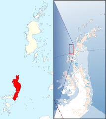
| Description | Locator map of Lavoisier Island in the Biscoe Islands |
| Date | |
| Source | Biscoe Islands, BAT.svg |
| Author | Hogweard |
| Permission (Reusing this file) |
This file is licensed under the Creative Commons Attribution 1.0 Generic license. Attribution: Antarctic Digital Database
|
File history
Click on a date/time to view the file as it appeared at that time.
| Date/Time | Thumbnail | Dimensions | User | Comment | |
|---|---|---|---|---|---|
| current | 23:15, 25 February 2022 | | 318 × 356 (1.11 MB) | Hogweard | Fill error |
File usage
The following file is a duplicate of this file (more details):
- File:Lavoisier Island - Biscoe Islands, BAT.svg from a shared repository
The following page links to this file: