File:Lairig Ghru and Lairig an Laoigh.svg
From Wikishire

Size of this preview: 360 × 599 pixels. Other resolution: 144 × 240 pixels.
Original file (SVG file, nominally 1,502 × 2,500 pixels, file size: 1 MB)
Summary
| Description |
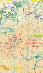
English: Lairig Ghru and Lairig an Laoigh - glacial passes and drove roads through the Cairngorm mountains inw: Scotland |
| Date | |
| Source | Own work and Ordnance Survey OpenData 1:250 000 Scale Colour Raster. Converted from File:Ordnance Survey 1-250000 - NH.tif, File:Ordnance Survey 1-250000 - NJ.tif, File:Ordnance Survey 1-250000 - NN.tif, File:Ordnance Survey 1-250000 - NO.tif |
| Author | Thincat and Ordnance Survey |
Licensing
I, the copyright holder of this work, hereby publish it under the following license:
This file is licensed under the Creative Commons Attribution-Share Alike 3.0 Unported license.
- You are free:
- to share – to copy, distribute and transmit the work
- to remix – to adapt the work
- Under the following conditions:
- attribution – You must give appropriate credit, provide a link to the license, and indicate if changes were made. You may do so in any reasonable manner, but not in any way that suggests the licensor endorses you or your use.
- share alike – If you remix, transform, or build upon the material, you must distribute your contributions under the same or compatible license as the original.
This file is licensed by the Ordnance Survey of the United Kingdom under their OS OpenData License
In short: you are free to distribute and modify the file as long as you attribute (including year), the Ordnance Survey. Attribution: Contains Ordnance Survey data © Crown copyright and database right (year) Note: Derivative works can be licensed under any Creative Commons Attribution 3.0 Licence. |
.svg)
|
This file is licensed under the United Kingdom Open Government Licence v3.0. |
See also: Meta for information on usage on Wikimedia wikis.
|
File history
Click on a date/time to view the file as it appeared at that time.
| Date/Time | Thumbnail | Dimensions | User | Comment | |
|---|---|---|---|---|---|
| current | 16:53, 5 May 2016 | | 1,502 × 2,500 (1 MB) | Thincat | Possibly slightly better route for north part of Lairig an Laoigh |
File usage
The following file is a duplicate of this file (more details):
- File:Lairig Ghru and Lairig an Laoigh.svg from a shared repository
The following 2 pages link to this file: