File:Lairig-ghru-sketch-map.jpg
From Wikishire

Size of this preview: 408 × 599 pixels. Other resolution: 163 × 240 pixels.
Original file (600 × 881 pixels, file size: 51 KB, MIME type: image/jpeg)
Summary
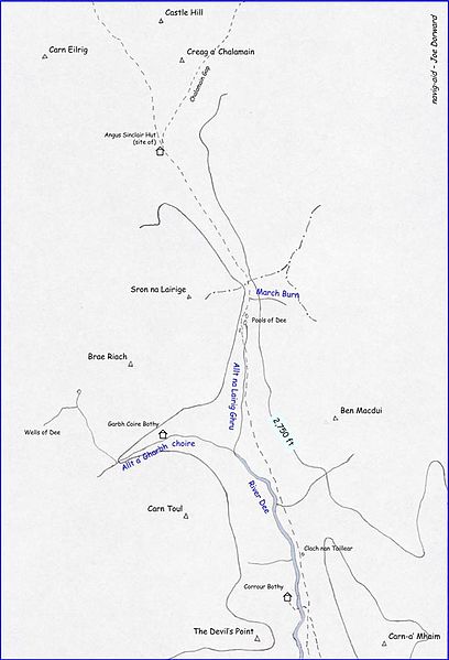
| Description | This navig-aid sketch map shows the Lairig Ghru route through the Cairngorms of Scotland with way-points, summits, and the 2,750ft contour-line marked |
| Date | |
| Source | Own work |
| Author | Joe Dorward (TheCreator) |
Licensing
| I, the copyright holder of this work, release this work into the public domain. This applies worldwide. In some countries this may not be legally possible; if so: I grant anyone the right to use this work for any purpose, without any conditions, unless such conditions are required by law. |
File history
Click on a date/time to view the file as it appeared at that time.
| Date/Time | Thumbnail | Dimensions | User | Comment | |
|---|---|---|---|---|---|
| current | 17:45, 15 April 2008 | | 600 × 881 (51 KB) | TheCreator | == Summary == {{Information |Description=A navig-aid sketch map of the ''Lairig Ghru'' route through the ''Cairngorms'' of ''Scotland'' showing way-points, summits, and the 2750ft contour-line |Source=self-made |Date=13MAR08 |Author= [[User:TheCreator|The |
File usage
The following file is a duplicate of this file (more details):
- File:Lairig-ghru-sketch-map.jpg from a shared repository
The following page links to this file: