File:Kirkby-in-Ashfield East Station geograph-2190886.jpg
From Wikishire

Size of this preview: 800 × 405 pixels. Other resolution: 320 × 162 pixels.
Original file (1,024 × 518 pixels, file size: 201 KB, MIME type: image/jpeg)
Summary
| Description |
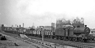
English: Down freight passing Kirkby-in-Ashfield East Station. View southward, towards Nottingham and Pye Bridge; ex-Midland Nottingham - Mansfield - Worksop line, junction of line from Pye Bridge. This station was closed on 6/9/65 and although the ex-Midland Nottingham - Mansfield - Worksop route was revived in the 1990s as the Robin Hood Line, through Kirkby this followed the alignment of the parallel ex-Great Northern (Leen Valley) line and the new Kirkby Station (opened on 17/11/96) was built on that alignment. The locomotive here heading a Down Class H freight is LMS 4F 0-6-0 No. 44531. |
| Date | Taken on 13 July 1963 |
| Source | From geograph.org.uk |
| Author | Ben Brooksbank |
| Permission (Reusing this file) |
Creative Commons Attribution Share-alike license 2.0 |
| Camera location | | View this and other nearby images on: OpenStreetMap |
|---|
Licensing

|
This image was taken from the Geograph project collection. See this photograph's page on the Geograph website for the photographer's contact details. The copyright on this image is owned by Ben Brooksbank and is licensed for reuse under the Creative Commons Attribution-ShareAlike 2.0 license.
|
This file is licensed under the Creative Commons Attribution-Share Alike 2.0 Generic license.
Attribution: Ben Brooksbank
- You are free:
- to share – to copy, distribute and transmit the work
- to remix – to adapt the work
- Under the following conditions:
- attribution – You must give appropriate credit, provide a link to the license, and indicate if changes were made. You may do so in any reasonable manner, but not in any way that suggests the licensor endorses you or your use.
- share alike – If you remix, transform, or build upon the material, you must distribute your contributions under the same or compatible license as the original.
File history
Click on a date/time to view the file as it appeared at that time.
| Date/Time | Thumbnail | Dimensions | User | Comment | |
|---|---|---|---|---|---|
| current | 17:09, 17 December 2010 | | 1,024 × 518 (201 KB) | Chevin | == {{int:filedesc}} == {{Information |Description={{en|1=Down freight passing Kirkby-in-Ashfield East Station View southward, towards Nottingham and Pye Bridge; ex-Midland Nottingham - Mansfield - Worksop line, junction of line from Pye Bridge. This stati |
File usage
The following file is a duplicate of this file (more details):
- File:Kirkby-in-Ashfield East Station geograph-2190886.jpg from a shared repository
The following page links to this file: