File:King's Castle, Wells LIDAR (DTM 1m).png
From Wikishire
No higher resolution available.
King's_Castle,_Wells_LIDAR_(DTM_1m).png (417 × 294 pixels, file size: 117 KB, MIME type: image/png)
.png)
Summary
| Description |
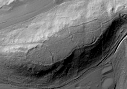
English: A LIDAR image of King's Castle, Wells, Somerset, using QGIS (min 90, max 160; contrast 100). |
| Date | |
| Source |
Own work English: based on the Environment Agency's LIDAR Open Data (ST5745 & ST5645 DTM 1m) |
| Author | Yodin |
Licensing
I, the copyright holder of this work, hereby publish it under the following license:
This file is licensed under the Creative Commons Attribution-Share Alike 4.0 International license.
- You are free:
- to share – to copy, distribute and transmit the work
- to remix – to adapt the work
- Under the following conditions:
- attribution – You must give appropriate credit, provide a link to the license, and indicate if changes were made. You may do so in any reasonable manner, but not in any way that suggests the licensor endorses you or your use.
- share alike – If you remix, transform, or build upon the material, you must distribute your contributions under the same or compatible license as the original.
.svg)
|
This file is licensed under the United Kingdom Open Government Licence v3.0. |
| Attribution:https://data.gov.uk/dataset/lidar-composite-dtm-1m1 | |
See also: Meta for information on usage on Wikimedia wikis.
|
File history
Click on a date/time to view the file as it appeared at that time.
| Date/Time | Thumbnail | Dimensions | User | Comment | |
|---|---|---|---|---|---|
| current | 16:07, 9 February 2020 | | 417 × 294 (117 KB) | Yodin | Rerendering using QGIS 3.4 with Hillshade |
File usage
The following file is a duplicate of this file (more details):
.png)
- File:King's Castle, Wells LIDAR (DTM 1m).png from a shared repository
The following page links to this file:
.png)
.png)
.png&action=edit&redlink=1)
.png)
.png&printable=yes)
.png&action=info)