File:Kimbolton - geograph.org.uk - 302731.jpg
From Wikishire
No higher resolution available.
Kimbolton_-_geograph.org.uk_-_302731.jpg (640 × 428 pixels, file size: 103 KB, MIME type: image/jpeg)
Summary
| Description |
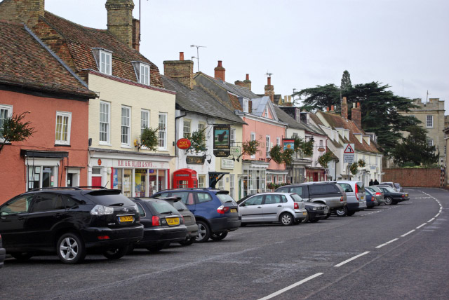
English: Kimbolton, near to Kimbolton, Cambridgeshire, Great Britain.
Looking along the High Street towards Kimbolton School. This was once the A45 (the principal Midlands - East Anglia route) and was a serious bottleneck, especially at the eastern end of the High Street where road negotiates a series of tight narrow bends. Today the road has been downgraded to the B645 (long-distance traffic is now routed via the A14, a few miles to the north) and as a result Kimbolton is a much more peaceful place. The attractive architecture, selection of small shops and pleasant pubs give the village an olde-world atmosphere. |
| Date | |
| Source | From geograph.org.uk; transferred by User:Skinsmoke using geograph_org2commons. |
| Author | Stephen McKay |
| Permission (Reusing this file) |
Creative Commons Attribution Share-alike license 2.0 |
| Camera location | | View this and other nearby images on: OpenStreetMap |
|---|
| Object location | | View this and other nearby images on: OpenStreetMap |
|---|
_region:GB-GBN_heading:90.00&language=en)
Licensing

|
This image was taken from the Geograph project collection. See this photograph's page on the Geograph website for the photographer's contact details. The copyright on this image is owned by Stephen McKay and is licensed for reuse under the Creative Commons Attribution-ShareAlike 2.0 license.
|
This file is licensed under the Creative Commons Attribution-Share Alike 2.0 Generic license.
Attribution: Stephen McKay
- You are free:
- to share – to copy, distribute and transmit the work
- to remix – to adapt the work
- Under the following conditions:
- attribution – You must give appropriate credit, provide a link to the license, and indicate if changes were made. You may do so in any reasonable manner, but not in any way that suggests the licensor endorses you or your use.
- share alike – If you remix, transform, or build upon the material, you must distribute your contributions under the same or compatible license as the original.
File history
Click on a date/time to view the file as it appeared at that time.
| Date/Time | Thumbnail | Dimensions | User | Comment | |
|---|---|---|---|---|---|
| current | 17:46, 25 September 2010 | | 640 × 428 (103 KB) | File Upload Bot (Magnus Manske) | == {{int:filedesc}} == {{Information |Description={{en|1=Kimbolton, near to Kimbolton, Cambridgeshire, Great Britain. Looking along the High Street towards Kimbolton School. This was once the A45 (the principal Midlands - East Anglia route) and was a seri |
File usage
The following file is a duplicate of this file (more details):
- File:Kimbolton - geograph.org.uk - 302731.jpg from a shared repository
The following page links to this file: