File:Kent Rivers.svg
From Wikishire

Size of this preview: 800 × 525 pixels. Other resolution: 320 × 210 pixels.
Original file (SVG file, nominally 1,839 × 1,207 pixels, file size: 125 KB)
Summary
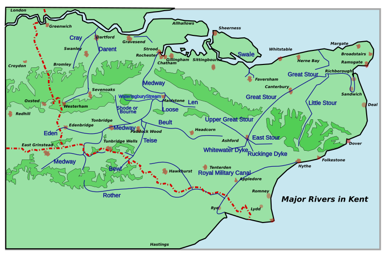
| Description | A map of the principal rivers in Kent. Kent Rivers can have two or more names- can divide and empty into different rivers. The map was inspired by Jessop, Kent History Illustrated, with freehand additions from OS maps and AtoZs . Please inform me of errors and omissions via my Talk page. Constructed using Inkscape, so there may be rendering problems. |
| Date | (UTC) |
| Source |
This file was derived from: Kent Town Rivers.svg: |
| Author |
|
| This is a retouched picture, which means that it has been digitally altered from its original version. Modifications: Names larger, better boundaries. The original can be viewed here: Kent Town Rivers.svg:
|
Licensing
I, the copyright holder of this work, hereby publish it under the following licenses:
This file is licensed under the Creative Commons Attribution 2.5 Generic license.
- You are free:
- to share – to copy, distribute and transmit the work
- to remix – to adapt the work
- Under the following conditions:
- attribution – You must give appropriate credit, provide a link to the license, and indicate if changes were made. You may do so in any reasonable manner, but not in any way that suggests the licensor endorses you or your use.
| This file is licensed under the Creative Commons Attribution-Share Alike 3.0 Unported license. | ||
| ||
| This licensing tag was added to this file as part of the GFDL licensing update. |

|
Permission is granted to copy, distribute and/or modify this document under the terms of the GNU Free Documentation License, Version 1.2 or any later version published by the Free Software Foundation; with no Invariant Sections, no Front-Cover Texts, and no Back-Cover Texts. A copy of the license is included in the section entitled GNU Free Documentation License. |
You may select the license of your choice.
Original upload log
This image is a derivative work of the following images:
- File:Kent_Town_Rivers.svg licensed with Cc-by-2.5, Cc-by-sa-3.0-migrated, GFDL
- 2007-11-18T23:14:46Z ClemRutter 1839x1207 (123429 Bytes) Added the Wateringbury Stream.
- 2007-06-12T22:24:53Z ClemRutter 1839x1207 (122106 Bytes) == Summary == {{Information |Description=A map of the principal rivers in Kent. Kent Rivers can have two or more names- can divide and empty into different rivers. The map was inspired by Jessop, Kent History Illustrated, wit
Uploaded with derivativeFX
File history
Click on a date/time to view the file as it appeared at that time.
| Date/Time | Thumbnail | Dimensions | User | Comment | |
|---|---|---|---|---|---|
| current | 22:17, 30 April 2012 | | 1,839 × 1,207 (125 KB) | Hogweard | == {{int:filedesc}} == {{Information |Description=A map of the principal rivers in Kent. Kent Rivers can have two or more names- can divide and empty into different rivers. The map was inspired by Jessop, Kent History Illustrated, with freehand additio... |
File usage
The following file is a duplicate of this file (more details):
- File:Kent Rivers.svg from a shared repository
The following page links to this file: