File:JoinvilleIsland Terra MODIS.jpg
From Wikishire
No higher resolution available.
JoinvilleIsland_Terra_MODIS.jpg (344 × 350 pixels, file size: 36 KB, MIME type: image/jpeg)
Summary
| Description |
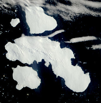
English: From top to bottom: D'Urville Island, Joinville Island (largest) and Dundee Island |
| Date | |
| Source | , originally from NASA Earth Observatory |
| Author | The MODIS Rapid Response Team at NASA GSFC |

Licensing
| This file is in the public domain in the United States because it was solely created by NASA. NASA copyright policy states that "NASA material is not protected by copyright unless noted". (See Template:PD-USGov, NASA copyright policy page or JPL Image Use Policy.) | ||
 |
Warnings:
|
File history
Click on a date/time to view the file as it appeared at that time.
| Date/Time | Thumbnail | Dimensions | User | Comment | |
|---|---|---|---|---|---|
| current | 15:42, 27 September 2015 | | 344 × 350 (36 KB) | SteinsplitterBot | Bot: Image rotated by 90° |
File usage
The following file is a duplicate of this file (more details):
- File:JoinvilleIsland Terra MODIS.jpg from a shared repository
The following 2 pages link to this file: