File:Inner Hebrides topographic.svg
From Wikishire

Size of this preview: 376 × 599 pixels. Other resolution: 151 × 240 pixels.
Original file (SVG file, nominally 785 × 1,250 pixels, file size: 718 KB)
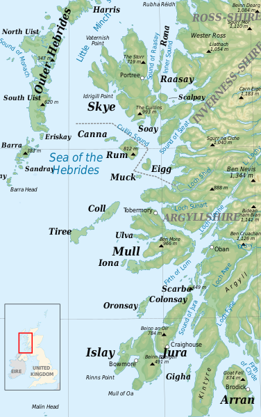
| Description | The Inner Hebrides, topographic map | ||
| Date | |||
| Source | File:Hebrides and The Minch.svg | ||
| Author | Hogweard | ||
| Permission (Reusing this file) |
I, the copyright holder of this work, hereby publish it under the following licenses:
This file is licensed under the Creative Commons Attribution-Share Alike 4.0 International, 3.0 Unported, 2.5 Generic, 2.0 Generic and 1.0 Generic license.
You may select the license of your choice. |
| This is a retouched picture, which means that it has been digitally altered from its original version. Modifications: Narrowed the area to the Inner Hebrides, increased type size, added county boundaries. The original can be viewed here: Hebrides and The Minch.svg:
|
Attribution
(required by the license)
© Sémhur / Wikimedia Commons /
© Sémhur / Wikimedia Commons
| Camera location | | View this and other nearby images on: OpenStreetMap |
|---|
File history
Click on a date/time to view the file as it appeared at that time.
| Date/Time | Thumbnail | Dimensions | User | Comment | |
|---|---|---|---|---|---|
| current | 21:38, 21 June 2014 | | 785 × 1,250 (718 KB) | Hogweard | {{Information |Description=The Inner Hebrides, topographic map |Source=File:Hebrides and The Minch.svg |Date=2014-06-21 |Author=Hogweard |Permission={{self|FAL|cc-by-sa-all}} |other_versions= }} {{RetouchedPicture|Narrowed the area to the Inner He... |
File usage
The following file is a duplicate of this file (more details):
- File:Inner Hebrides topographic.svg from a shared repository
The following page links to this file: