File:Hornes Place and Chapel, near Appledore Kent - geograph.org.uk - 41648.jpg
From Wikishire
No higher resolution available.
Hornes_Place_and_Chapel,_near_Appledore_Kent_-_geograph.org.uk_-_41648.jpg (640 × 427 pixels, file size: 122 KB, MIME type: image/jpeg)
Summary
| Description |
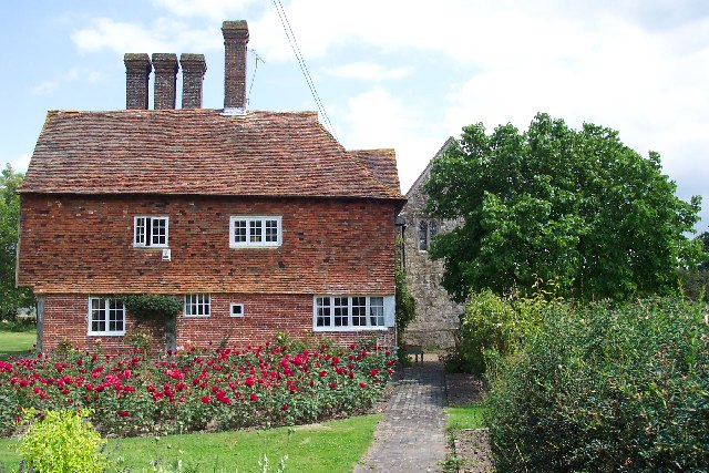
English: Hornes Place and Chapel, near Appledore Kent. A 14th-century domestic chapel which was once attached to the manor house. During the Peasants Revolt in 1381 supporters of Wat Tyler in Appledore sacked Horne's Place. The house and chapel are privately owned but access to the chapel can be arranged through English Heritage. |
| Date | |
| Source | From geograph.org.uk |
| Author | Ron Strutt |
| Attribution (required by the license) | Ron Strutt / Hornes Place and Chapel, near Appledore Kent / |
| Camera location | | View this and other nearby images on: OpenStreetMap |
|---|
_heading:67.00&language=en)
| Object location | | View this and other nearby images on: OpenStreetMap |
|---|
_heading:67.00&language=en)
This is a photo of listed building number 1362879. |
Licensing

|
This image was taken from the Geograph project collection. See this photograph's page on the Geograph website for the photographer's contact details. The copyright on this image is owned by Ron Strutt and is licensed for reuse under the Creative Commons Attribution-ShareAlike 2.0 license.
|
This file is licensed under the Creative Commons Attribution-Share Alike 2.0 Generic license.
Attribution: Ron Strutt
- You are free:
- to share – to copy, distribute and transmit the work
- to remix – to adapt the work
- Under the following conditions:
- attribution – You must give appropriate credit, provide a link to the license, and indicate if changes were made. You may do so in any reasonable manner, but not in any way that suggests the licensor endorses you or your use.
- share alike – If you remix, transform, or build upon the material, you must distribute your contributions under the same or compatible license as the original.
File history
Click on a date/time to view the file as it appeared at that time.
| Date/Time | Thumbnail | Dimensions | User | Comment | |
|---|---|---|---|---|---|
| current | 15:41, 30 January 2010 | | 640 × 427 (122 KB) | GeographBot | == {{int:filedesc}} == {{Information |description={{en|1=Hornes Place and Chapel, near Appledore Kent. A 14th-century domestic chapel which was once attached to the manor house. During the Peasants Revolt in 1381 supporters of Wat Tyler in Appledore sacke |
File usage
The following file is a duplicate of this file (more details):
- File:Hornes Place and Chapel, near Appledore Kent - geograph.org.uk - 41648.jpg from a shared repository
The following 2 pages link to this file: