File:Hillside above Settle and the Langcliffe mills - geograph.org.uk - 782271.jpg
From Wikishire

Size of this preview: 624 × 600 pixels. Other resolution: 250 × 240 pixels.
Original file (640 × 615 pixels, file size: 112 KB, MIME type: image/jpeg)
Summary
| Description |
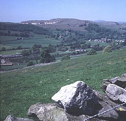
English: Hillside above Settle and the Langcliffe mills Looking north-west across the Ribble valley to Giggleswick Scar, with Ingleborough in the distance to the right. Plenty of sheep pasture on the hillside and hard to believe this was once a major industrial setting. Below in the valley are two weaving mills, originally powered by the ample water supply and later supplemented by steam power. To the left is Watershed Mill, now a shopping centre and a good place to buy a woolly jumper. To the right is the impressive High Mill, built in 1783 by George and William Clayton, and furnished with Richard Arkwright machinery. At the time it was one of the largest cotton mills in the country. Now the home of a packaging company.
http://www.watershedmill.co.uk/ http://www.outofoblivion.org.uk/record.asp?id=324 http://www.northcravenheritage.org.uk/nchtjournal/Journals/1996/J96A7.html |
| Date | |
| Source | From geograph.org.uk |
| Author | Trevor Rickard |
| Attribution (required by the license) | Trevor Rickard / Hillside above Settle and the Langcliffe mills / |
| Camera location | | View this and other nearby images on: OpenStreetMap |
|---|
_heading:315.00&language=en)
| Object location | | View this and other nearby images on: OpenStreetMap |
|---|
_heading:315.00&language=en)
Licensing

|
This image was taken from the Geograph project collection. See this photograph's page on the Geograph website for the photographer's contact details. The copyright on this image is owned by Trevor Rickard and is licensed for reuse under the Creative Commons Attribution-ShareAlike 2.0 license.
|
This file is licensed under the Creative Commons Attribution-Share Alike 2.0 Generic license.
Attribution: Trevor Rickard
- You are free:
- to share – to copy, distribute and transmit the work
- to remix – to adapt the work
- Under the following conditions:
- attribution – You must give appropriate credit, provide a link to the license, and indicate if changes were made. You may do so in any reasonable manner, but not in any way that suggests the licensor endorses you or your use.
- share alike – If you remix, transform, or build upon the material, you must distribute your contributions under the same or compatible license as the original.
File history
Click on a date/time to view the file as it appeared at that time.
| Date/Time | Thumbnail | Dimensions | User | Comment | |
|---|---|---|---|---|---|
| current | 01:31, 20 February 2011 | | 640 × 615 (112 KB) | GeographBot | == {{int:filedesc}} == {{Information |description={{en|1=Hillside above Settle and the Langcliffe mills Looking north-west across the Ribble valley to Giggleswick Scar, with Ingleborough in the distance to the right. Plenty of sheep pasture on the hillsid |
File usage
The following file is a duplicate of this file (more details):
- File:Hillside above Settle and the Langcliffe mills - geograph.org.uk - 782271.jpg from a shared repository
The following page links to this file: