File:Hatfield Chase map.jpg
From Wikishire

Size of this preview: 800 × 547 pixels. Other resolution: 320 × 219 pixels.
Original file (1,108 × 757 pixels, file size: 139 KB, MIME type: image/jpeg)

|
This map image could be re-created using vector graphics as an SVG file. This has several advantages; see Commons:Media for cleanup for more information. If an SVG form of this image is available, please upload it and afterwards replace this template with
{{vector version available|new image name}}.
It is recommended to name the SVG file “Hatfield Chase map.svg”—then the template Vector version available (or Vva) does not need the new image name parameter. |


Summary
| Description |
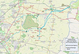
English: Map of Hatfield Chase, England showing Internal Drainage Board area, high level carriers and pumping stations |
| Date | |
| Source | Own work on Open Street Map base layer |
| Author | Bob1960evens |
Licensing
I, the copyright holder of this work, hereby publish it under the following license:
This file is licensed under the Creative Commons Attribution-Share Alike 3.0 Unported license.
- You are free:
- to share – to copy, distribute and transmit the work
- to remix – to adapt the work
- Under the following conditions:
- attribution – You must give appropriate credit, provide a link to the license, and indicate if changes were made. You may do so in any reasonable manner, but not in any way that suggests the licensor endorses you or your use.
- share alike – If you remix, transform, or build upon the material, you must distribute your contributions under the same or compatible license as the original.
File history
Click on a date/time to view the file as it appeared at that time.
| Date/Time | Thumbnail | Dimensions | User | Comment | |
|---|---|---|---|---|---|
| current | 16:54, 14 September 2020 | | 1,108 × 757 (139 KB) | Bob1960evens | Details overlaid on Open Street Map base layer |
File usage
The following file is a duplicate of this file (more details):
- File:Hatfield Chase map.jpg from a shared repository
The following page links to this file: