File:Harwich Harbour 1804.png
From Wikishire

Size of this preview: 449 × 599 pixels. Other resolution: 180 × 240 pixels.
Original file (2,498 × 3,331 pixels, file size: 1,012 KB, MIME type: image/png)
Summary
| Description |
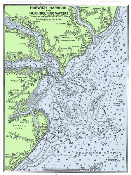
English: This is a chart of the approaches to Harwich and Felixstowe that was first published in 1804. This version is from a book: Orwell Estuary, the story of Ipswich River by W.G.Arnott. The sea and the land have been coloured to make the chart easier to read. |
| Date | |
| Source | Originally published in 1804 from a survey by Graeme Spence |
| Author | Welkinridge |
Licensing
|
This work is in the public domain in its country of origin and other countries and areas where the copyright term is the author's life plus 100 years or fewer. | |
| This file has been identified as being free of known restrictions under copyright law, including all related and neighboring rights. | |
File history
Click on a date/time to view the file as it appeared at that time.
| Date/Time | Thumbnail | Dimensions | User | Comment | |
|---|---|---|---|---|---|
| current | 19:01, 21 June 2008 | | 2,498 × 3,331 (1,012 KB) | Welkinridge | {{Information |Description={{en|1=This is a chart of the approaches to Harwich and Felixstowe that was first published in 1804. This version is from a book: Orwell Estuary, the story of Ipswich River by W.G.Arnott. The sea and the land have been coloured |
File usage
The following file is a duplicate of this file (more details):
- File:Harwich Harbour 1804.png from a shared repository
The following page links to this file: