File:Great Bavington village centre - geograph.org.uk - 1176848.jpg
From Wikishire
No higher resolution available.
Great_Bavington_village_centre_-_geograph.org.uk_-_1176848.jpg (640 × 480 pixels, file size: 83 KB, MIME type: image/jpeg)
Summary
| Description |
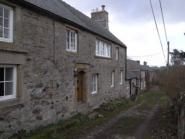
English: Great Bavington village centre These buildings stand at the very centre of Great Bavington which at one time was a much larger place than it is today. The house in the foreground is the oldest building still standing in the village and was built in 1625. The nearer part was once the "Harvest Home" public house, and subsequently the manse for the United Reformed Church across the way before being superseded by the new manse of 1854 adjacent to the Church.
The far end of the building housed the village school from 1855 until 1946. From 1949 the school building housed a Youth Hostel but it was closed in 1959 because of "unseemly behaviour" by the hostellers - what ever can that mean? The building is now divided into two private houses - Easter House (nearest the camera) and Easter Cottage. |
| Date | |
| Source | From geograph.org.uk |
| Author | Oliver Dixon |
| Attribution (required by the license) | Oliver Dixon / Great Bavington village centre / |
| Camera location | | View this and other nearby images on: OpenStreetMap |
|---|
_heading:67.00&language=en)
| Object location | | View this and other nearby images on: OpenStreetMap |
|---|
_heading:67.00&language=en)
Licensing

|
This image was taken from the Geograph project collection. See this photograph's page on the Geograph website for the photographer's contact details. The copyright on this image is owned by Oliver Dixon and is licensed for reuse under the Creative Commons Attribution-ShareAlike 2.0 license.
|
This file is licensed under the Creative Commons Attribution-Share Alike 2.0 Generic license.
Attribution: Oliver Dixon
- You are free:
- to share – to copy, distribute and transmit the work
- to remix – to adapt the work
- Under the following conditions:
- attribution – You must give appropriate credit, provide a link to the license, and indicate if changes were made. You may do so in any reasonable manner, but not in any way that suggests the licensor endorses you or your use.
- share alike – If you remix, transform, or build upon the material, you must distribute your contributions under the same or compatible license as the original.
File history
Click on a date/time to view the file as it appeared at that time.
| Date/Time | Thumbnail | Dimensions | User | Comment | |
|---|---|---|---|---|---|
| current | 17:27, 25 February 2011 | | 640 × 480 (83 KB) | GeographBot | == {{int:filedesc}} == {{Information |description={{en|1=Great Bavington village centre These buildings stand at the very centre of Great Bavington which at one time was a much larger place than it is today. The house in the foreground is the oldest build |
File usage
The following file is a duplicate of this file (more details):
- File:Great Bavington village centre - geograph.org.uk - 1176848.jpg from a shared repository
The following page links to this file: