File:Gough Island Landsat.jpg
From Wikishire

Size of this preview: 800 × 559 pixels. Other resolution: 320 × 223 pixels.
Original file (1,259 × 879 pixels, file size: 139 KB, MIME type: image/jpeg)
Summary
| Description |
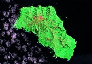
English: Landsat image of Gough Island, Tristan da Cunha, South Atlantic Ocean (Landsat S-29-40_2000) |
| Date | |
| Source | flickr |
| Author | NASA/USGS |
Licensing
| This file is in the public domain in the United States because it was solely created by NASA. NASA copyright policy states that "NASA material is not protected by copyright unless noted". (See Template:PD-USGov, NASA copyright policy page or JPL Image Use Policy.) | ||
 |
Warnings:
|
| Annotations | This image is annotated: View the annotations at Commons |
File history
Click on a date/time to view the file as it appeared at that time.
| Date/Time | Thumbnail | Dimensions | User | Comment | |
|---|---|---|---|---|---|
| current | 07:53, 12 July 2010 | | 1,259 × 879 (139 KB) | Telim tor | == {{int:filedesc}} == {{Information |Description={{en|Landsat image of Gough Island, Tristan da Cunha, South Atlantic Ocean (Landsat S-29-40_2000)}} |Source=[http://www.flickr.com/photos/evsmap/2418411184/ flickr] |Date=2000 |Author=NASA/USGS |Permission |
File usage
The following file is a duplicate of this file (more details):
- File:Gough Island Landsat.jpg from a shared repository
The following page links to this file: