File:Freshwater East Bay - geograph.org.uk - 1567080.jpg
From Wikishire
No higher resolution available.
Freshwater_East_Bay_-_geograph.org.uk_-_1567080.jpg (640 × 422 pixels, file size: 112 KB, MIME type: image/jpeg)
Summary
| Description |
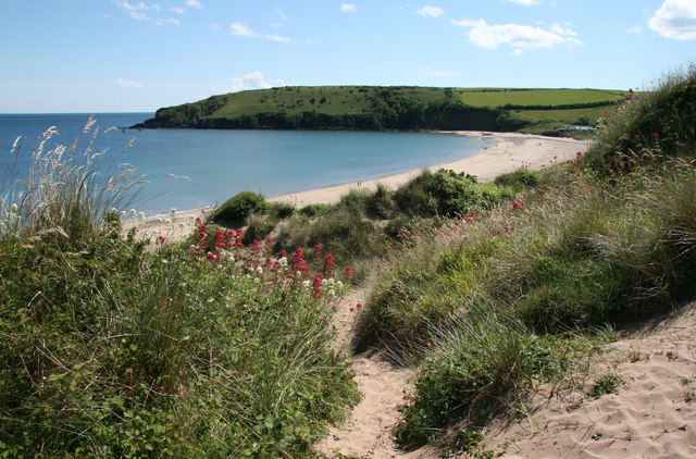
English: Freshwater East Bay View south from the dunes towards Trewent Point.
The headland is in the lowest part of the sequence of rocks known as the Old Red Sandstone, and includes a layer of volcanic ash (the Townsend Tuff, exposed on the inaccessible south side of the headland). The dunes extend northwards over the ridge on which the modern village has been built. A late period of sand encroachment (post 13th century) led to abandonment and burial of an early Christian settlement (radicarbon date c. 550AD). |
| Date | |
| Source | From geograph.org.uk |
| Author | Sid Howells |
| Attribution (required by the license) | Sid Howells / Freshwater East Bay / |
| Camera location | | View this and other nearby images on: OpenStreetMap |
|---|
_heading:202.00&language=en)
| Object location | | View this and other nearby images on: OpenStreetMap |
|---|
_heading:202.00&language=en)
Licensing

|
This image was taken from the Geograph project collection. See this photograph's page on the Geograph website for the photographer's contact details. The copyright on this image is owned by Sid Howells and is licensed for reuse under the Creative Commons Attribution-ShareAlike 2.0 license.
|
This file is licensed under the Creative Commons Attribution-Share Alike 2.0 Generic license.
Attribution: Sid Howells
- You are free:
- to share – to copy, distribute and transmit the work
- to remix – to adapt the work
- Under the following conditions:
- attribution – You must give appropriate credit, provide a link to the license, and indicate if changes were made. You may do so in any reasonable manner, but not in any way that suggests the licensor endorses you or your use.
- share alike – If you remix, transform, or build upon the material, you must distribute your contributions under the same or compatible license as the original.
File history
Click on a date/time to view the file as it appeared at that time.
| Date/Time | Thumbnail | Dimensions | User | Comment | |
|---|---|---|---|---|---|
| current | 16:53, 3 March 2011 | | 640 × 422 (112 KB) | GeographBot | == {{int:filedesc}} == {{Information |description={{en|1=Freshwater East Bay View south from the dunes towards Trewent Point. The headland is in the lowest part of the sequence of rocks known as the Old Red Sandstone, and includes a layer of volcanic a |
File usage
The following file is a duplicate of this file (more details):
- File:Freshwater East Bay - geograph.org.uk - 1567080.jpg from a shared repository
The following page links to this file: