File:Donegal. "Urris Hills Air Crash" Elevation 235 metres (770 feet) - geograph.org.uk - 1046694.jpg
From Wikishire
No higher resolution available.
Donegal._"Urris_Hills_Air_Crash"_Elevation_235_metres_(770_feet)_-_geograph.org.uk_-_1046694.jpg (640 × 480 pixels, file size: 122 KB, MIME type: image/jpeg)
_-_geograph.org.uk_-_1046694.jpg)
Summary
| Description |
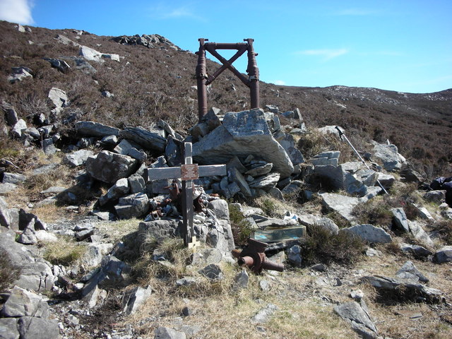
English: Donegal. "Urris Hills Air Crash" Elevation 235 metres (770 feet) On Good Friday, the 11 April 1941, a Vickers Wellington bomber crashed into the Urris Hills. Alfred Patrick Cattley, age 24 (Of Russian birth) and his crew of five perished at 3pm on the slopes of the mountain. Looking for the airfield at Limavady, they got lost in thick fog and mistook Lough Swilly for Lough Foyle.
It almost seems an obscenity that such a peaceful and beautiful place, six young airmen disorientated by thick fog and struggling to recognise a familiar landmark in unfamiliar terrain should die in such tragic circumstances. "Courtesy of the Derry Journal" |
| Date | |
| Source | From geograph.org.uk |
| Author | Michael Murtagh |
| Attribution (required by the license) | Michael Murtagh / Donegal. "Urris Hills Air Crash" Elevation 235 metres (770 feet) / |
| Camera location | | View this and other nearby images on: OpenStreetMap |
|---|
_-_geograph.org.uk_-_1046694.jpg¶ms=055.218662_N_-007.534070_E_globe:Earth_type:camera_source:geograph-irishgrid(C2970341389)_heading:90.00&language=en)
| Object location | | View this and other nearby images on: OpenStreetMap |
|---|
_-_geograph.org.uk_-_1046694.jpg¶ms=055.218662_N_-007.534070_E_globe:Earth_class:object_type:object_source:geograph-irishgrid(C2970341389)_heading:90.00&language=en)
Licensing

|
This image was taken from the Geograph project collection. See this photograph's page on the Geograph website for the photographer's contact details. The copyright on this image is owned by Michael Murtagh and is licensed for reuse under the Creative Commons Attribution-ShareAlike 2.0 license.
|
This file is licensed under the Creative Commons Attribution-Share Alike 2.0 Generic license.
Attribution: Michael Murtagh
- You are free:
- to share – to copy, distribute and transmit the work
- to remix – to adapt the work
- Under the following conditions:
- attribution – You must give appropriate credit, provide a link to the license, and indicate if changes were made. You may do so in any reasonable manner, but not in any way that suggests the licensor endorses you or your use.
- share alike – If you remix, transform, or build upon the material, you must distribute your contributions under the same or compatible license as the original.
File history
Click on a date/time to view the file as it appeared at that time.
| Date/Time | Thumbnail | Dimensions | User | Comment | |
|---|---|---|---|---|---|
| current | 21:04, 23 February 2011 | | 640 × 480 (122 KB) | GeographBot | == {{int:filedesc}} == {{Information |description={{en|1=Donegal. "Urris Hills Air Crash" Elevation 235 metres (770 feet) On Good Friday, the 11 April 1941, a Vickers Wellington bomber crashed into the Urris Hills. Alfred Patrick Cattley, age 24 (Of Russi |
File usage
The following file is a duplicate of this file (more details):
_-_geograph.org.uk_-_1046694.jpg)
The following page links to this file:
_-_geograph.org.uk_-_1046694.jpg)
_-_geograph.org.uk_-_1046694.jpg)
_-_geograph.org.uk_-_1046694.jpg&action=edit&redlink=1)
_-_geograph.org.uk_-_1046694.jpg)
_-_geograph.org.uk_-_1046694.jpg&printable=yes)
_-_geograph.org.uk_-_1046694.jpg&action=info)