File:Daily Shoot, Hereford Cathedral Feb 2011.jpg

| Description |
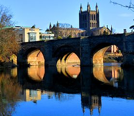
Daily shoot theme was "a leading line"and wanted to try this shot for a long time. The reflection of the bridge and cathedral lead the eye from bottom to top. The river is the river Wye. Bridge constructed in 1490, and of course the cathedral from 900 AD. This is also the classic tourist shot of the city that you can see on all of the brochures and websites and I always thought I could do a better job! Just needed a tripod (again) <a href="https://www.flickr.com/photos/leshaines123/">www.flickr.com/photos/leshaines123/</a> <a href="http://pinterest.com/leshaines/photography-images-of-a-journey-through-life/" rel="nofollow">pinterest.com/leshaines/photography-images-of-a-journey-t...</a> <a href="http://www.facebook.com/leshainesImages" rel="nofollow">www.facebook.com/leshainesImages</a> |
||
| Date | |||
| Source | Flickr: Daily Shoot ~Hereford Cathedral Feb 2011 | ||
| Author | Les Haines | ||
| Permission (Reusing this file) |
This file is licensed under the Creative Commons Attribution 2.0 Generic license.
|
| Camera location | | View this and other nearby images on: OpenStreetMap |
|---|
File history
Click on a date/time to view the file as it appeared at that time.
| Date/Time | Thumbnail | Dimensions | User | Comment | |
|---|---|---|---|---|---|
| current | 15:28, 17 February 2013 | | 2,936 × 2,546 (4.24 MB) | Flickr upload bot | Uploaded from http://flickr.com/photo/46018453@N06/5441723385 using Flickr upload bot |
File usage
The following file is a duplicate of this file (more details):
- File:Daily Shoot, Hereford Cathedral Feb 2011.jpg from a shared repository
The following page links to this file: