File:Crosshill Cross - geograph.org.uk - 212188.jpg
From Wikishire
Size of this preview: 450 × 600 pixels. Other resolution: 180 × 240 pixels.
Original file (480 × 640 pixels, file size: 94 KB, MIME type: image/jpeg)
Summary
| Description |
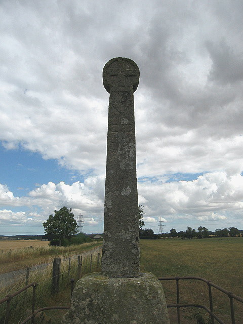
English: Crosshill Cross. The cross dates from the twelfth century, and is thought to be a memorial stone erected to mark the grave of an important person. The cross is just under 3m high, and is inserted into a large block of stone that is itself over 1m in height. The shaft tapers towards the top, terminating in a disc on which a cross is carved on either side. Each side of the shaft bears carved decoration. A naked man and greyhound on the east side, and a coat of arms on the west, south and possibly the north side. On the west and north sides, there are also depictions of a carved cross. A sword is depicted on the south side. The symbols carved on this cross suggest that the person whom it commemorates may have been to the Crusades. |
| Date | |
| Source | From geograph.org.uk |
| Author | Lisa Jarvis |
| Camera location | | View this and other nearby images on: OpenStreetMap |
|---|
_heading:67.00&language=en)
| Object location | | View this and other nearby images on: OpenStreetMap |
|---|
_heading:67.00&language=en)
Licensing

|
This image was taken from the Geograph project collection. See this photograph's page on the Geograph website for the photographer's contact details. The copyright on this image is owned by Lisa Jarvis and is licensed for reuse under the Creative Commons Attribution-ShareAlike 2.0 license.
|
This file is licensed under the Creative Commons Attribution-Share Alike 2.0 Generic license.
Attribution: Lisa Jarvis
- You are free:
- to share – to copy, distribute and transmit the work
- to remix – to adapt the work
- Under the following conditions:
- attribution – You must give appropriate credit, provide a link to the license, and indicate if changes were made. You may do so in any reasonable manner, but not in any way that suggests the licensor endorses you or your use.
- share alike – If you remix, transform, or build upon the material, you must distribute your contributions under the same or compatible license as the original.
- Remove redundant categories and try to put this image in the most specific category/categories
- Remove this template
- The location categories are based on information from this geonames tool and this OpenStreetMap tool combined with a database. You can also have a look at this tool from mysociety.
- The topic category from Geograph was Cross (find similar images at Geograph)
File history
Click on a date/time to view the file as it appeared at that time.
| Date/Time | Thumbnail | Dimensions | User | Comment | |
|---|---|---|---|---|---|
| current | 21:00, 31 January 2010 | | 480 × 640 (94 KB) | GeographBot | == {{int:filedesc}} == {{Information |description={{en|1=Crosshill Cross. The cross dates from the twelfth century, and is thought to be a memorial stone erected to mark the grave of an important person. The cross is just under 3m high, and is inserted in |
File usage
The following file is a duplicate of this file (more details):
- File:Crosshill Cross - geograph.org.uk - 212188.jpg from a shared repository
The following page links to this file: