File:Croghan-map.jpg
From Wikishire

Size of this preview: 600 × 600 pixels. Other resolution: 240 × 240 pixels.
Original file (1,181 × 1,181 pixels, file size: 159 KB, MIME type: image/jpeg)
Summary
| Description |
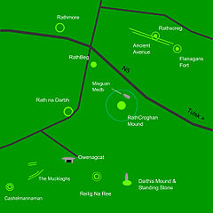
English: Map of the main sites around Rathcroghan including main & minor roads. Created on Flash Oct. 2007 |
| Date | 17 November 2007 (original upload date) |
| Source | Transferred from en.wikipedia to Commons by Reinhard Kraasch using CommonsHelper. |
| Author | Davsca at English Wikipedia |
Licensing
Davsca at English Wikipedia, the copyright holder of this work, hereby publishes it under the following licenses:

|
Permission is granted to copy, distribute and/or modify this document under the terms of the GNU Free Documentation License, Version 1.2 or any later version published by the Free Software Foundation; with no Invariant Sections, no Front-Cover Texts, and no Back-Cover Texts. A copy of the license is included in the section entitled GNU Free Documentation License. |
This file is licensed under the Creative Commons Attribution 3.0 Unported license.
Attribution: Davsca at English Wikipedia
- You are free:
- to share – to copy, distribute and transmit the work
- to remix – to adapt the work
- Under the following conditions:
- attribution – You must give appropriate credit, provide a link to the license, and indicate if changes were made. You may do so in any reasonable manner, but not in any way that suggests the licensor endorses you or your use.
You may select the license of your choice.
Original upload log
The original description page was here. All following user names refer to en.wikipedia.
- 2007-11-17 17:45 Davsca 1181×1181× (162458 bytes) Map of the main sites around Rathcroghan including main & minor roads. Created on Flash Oct. 2007
File history
Click on a date/time to view the file as it appeared at that time.
| Date/Time | Thumbnail | Dimensions | User | Comment | |
|---|---|---|---|---|---|
| current | 21:18, 14 March 2011 | | 1,181 × 1,181 (159 KB) | File Upload Bot (Magnus Manske) | {{BotMoveToCommons|en.wikipedia|year={{subst:CURRENTYEAR}}|month={{subst:CURRENTMONTHNAME}}|day={{subst:CURRENTDAY}}}} {{Information |Description={{en|Map of the main sites around Rathcroghan including main & minor roads. Created on Flash Oct. 2007}} |So |
File usage
The following file is a duplicate of this file (more details):
- File:Croghan-map.jpg from a shared repository
The following page links to this file: